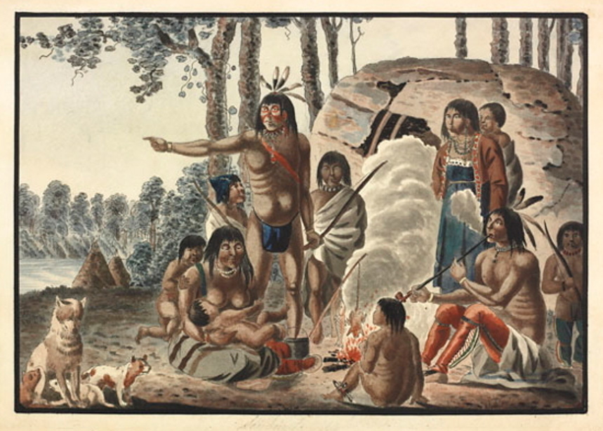
Anishinaabe (Saulteaux) family at Red River circa 1821, long before Dawson or the road. A painting by Peter Rindisbacher. Source: Library and Archives Canada/Peter Rindisbacher collection/e008299399. Retrieved June 21, 2020 from The Begbie Contest Society. (n.d.) Canadian Primary Sources in the Classroom – Riel and Manitoba . Rindisbacher's sketches of the Canadian fur route are the only known drawings today that show what it was like to travel that much-used route at the time. His paintings have become important documents that provide some understanding for researchers studying the early settlement in the western regions of North America. Rindisbacher has come to occupy an important place in the history of Canadian art. Today 140 of Peter Rindisbacher's images survive. Peter Risdinbacher died August 13, 1834, at the age 28. Source: Siamandas, G. (n.d.). Peter Rindisbacher: The Boy Artist from Red River. Retrieved July 1, 2020 from Peter Rindisbacher Boy Artist from Red River BY GEORGE SIAMANDAS
“In the spring of 1859, having learned that a party fitted out by the people of Red River, who at that time took a great deal of interest in promoting the development of the country, had been baffled in an attempt to take horses through to the Lake of the Woods, had in fact got bewildered in swamps, from which they had experienced much difficulty in extricating themselves, and as the impression as to that section of the country being impracticable for roads was thus gaining confirmation, I hasted to the Lake of the Woods, with the most active of my assistants, and proceeding to its western extremity had the good fortune to secure the services of an Indian Chief, who undertook to show us ground on which the country could be crossed.
"Leaving my assistants to find their way across with the Chief, I proceeded by way of the Winnipeg (River) to the Red River Settlement, where I had not long to wait for their arrival. They reported that the Chief had led them to a gravelly ridge which extended, with but few breaks, for a long distance across the most swampy parts of the country, and that the remains of Indian encampments (showed) that it had been much used as a pathway, in times long past.
"A number of men were immediately engaged in the Settlement and sent to open the line which had been traced, in such a way as to render it passable for horses; and over this line our party rode clear through to the Lake of the Woods, on horseback.
"The line thus opened was used afterwards as a Post road for the conveyance of Mails on horseback, and it requires but slight knowledge of engineering to understand that ground, over which horses can be ridden, is not so swampy as to be impracticable for roads.”
Simon Dawson, Surveyor and engineer of the Dawson Road, 1868
Source: Dawson, S. J. (1868). Report on the line of route between Lake Superior and the Red River Settlement (P.9). House of Commons. Hunter, Rose & Company: Ottawa. Also published by I.B. Taylor, 1869: Ottawa. Retrieved June 3, 2020 from http://peel.library.ualberta.ca/bibliography/481.html. For French version, see Rapport sur les traces de la route entre le lac Supérieur et l’établissement de la Rivière-Rouge. Ottawa : Hunter, Rose et Lemieux, 1868, retrieved June 3, 2020 from http://peel.library.ualberta.ca/bibliography/480.html
Back to St. Boniface Heritage Tour page | Top
Previous page: Simon J. Dawson: Surveyor, Civil Engineer, Office Holder, and Politician
Next page: Lumber for the “Mother Church of Western Canada”