SEE GOOGLE MAP LOCATION 
POINT OF INTEREST: Original Municipal Building in the Town of Ste. Anne – “Hôtel de ville”
Cairn Commemorating the Dawson Road | Origins of Sainte-Anne-des-Chênes
HISTORICAL NUGGETS: Last Survivor of the Old West: Alexandre Bériault
From the underpass continue east on Dawson Road #207. In approx 1.5 kilometres (watch for the crosswalk) on the left (north) side, at the corner of #207 and Arena Road (goes north), you will see the Original Municipal Building and Cairn. The church is just east on the south side of #207 so feel free to park and walk to both points.
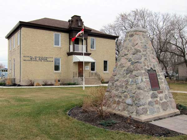
Original Municipal Building in the Town of Ste. Anne – “Hôtel de ville”
Located in the heart of the town of Ste. Anne on Centrale Avenue is a handsome historic municipal building in front of which lies the pyramidal stone cairn for the Dawson Road.
The Rural Municipality of Ste. Anne was incorporated in February 1881. In 1890, it was amalgamated with the Rural Municipality of LaBroquerie. It became re-established by an Act of the Legislature in 1908. The historic municipal building was erected in 1910. West side inscription reads: “1884 Cour de Compte 1910”.
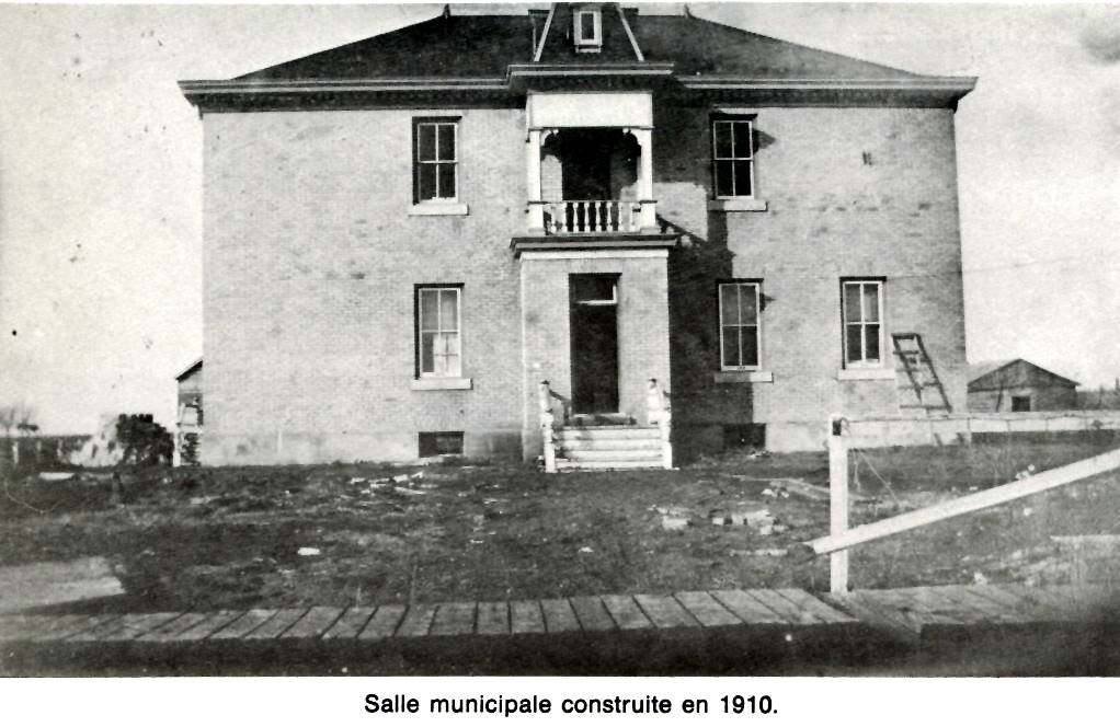
Photo courtesy of Norm Lavack.
This building is now privately owned. A new municipal building has since been erected near the junction of Highway 12 and Route 210.
Source: Historic Sites of Manitoba: Dawson Road Monument (Centrale Avenue, Ste. Anne)
Source: Historic Sites of Manitoba: Dawson Road Monument (Centrale Avenue, Ste. Anne)
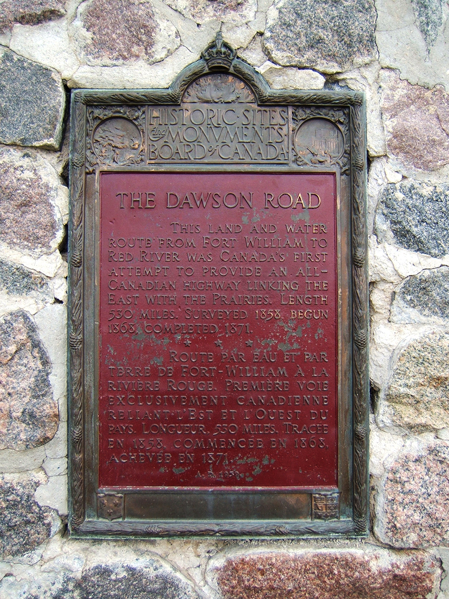
Cairn Commemorating the Dawson Road
Erected in 1939 in front of the historic Municipal town hall, this cairn commemorates the construction of the Dawson Road at the westernmost point where work was begun in 1868. At the foot of this monument is a forgotten time capsule, buried in 1970, during Manitoba’s Centennial celebrations.
Source: Historic Sites of Manitoba: Dawson Road Monument (Centrale Avenue, Ste. Anne)
Origins of Sainte-Anne-des-Chênes
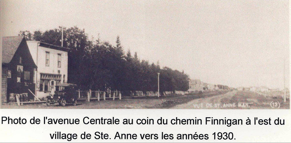
Photograph of Centrale Avenue at the corner of Piney Road (later Finnigan Road) east of the village of Ste. Anne circa 1930s. Image shows the store of Mr. Isaie Richer. This store was built in 1885 and sold in 1911 to Mr. Louis Dufresne. Source: Blom, R.R. (1980, April). Taché Rural Municipality 1880-1980 (P.171). Commissioned by The Council of the Rural Municipality of Taché. Derksen Printers, Steinbach: Manitoba. Retrieved from University of Manitoba digital collections June 3, 2020, http://hdl.handle.net/10719/3055598
“Pointe des Chênes or Grande Pointe des Chênes, now Sainte-Anne-des-Chênes, Manitoba: This area was purchased by Métis and French settlers in 1852 from Na-sa-kee-byness (Flying Down Bird) also known as Grandes Oreilles (II) the Chief of the Roseau River Band. This was a preferred location for woodcutting because of the large oak groves along the banks of the Seine River. Sainte-Anne-des-Chênes was the first to organize as a parish in 1856 despite there being older settlements with a church in the Red River Colony. It is interesting to note that the Ste. Anne region supplied the lumber for the construction of the St. Boniface Cathedral.
"The area provided good game hunting as well as lumber for the Métis people who were the early residents. Many of these families were itinerant buffalo hunters. A permanent settlement began in 1850s and this increased after the 1852 flood when many Métis moved to the higher ground at Pointe-des-Chênes.”
Lawrence Barkwell, author
Source: Barkwell, L. J. (2016). The Metis Homeland: Its Settlements and Communities (P.152). Louis Riel Institute. Rights pending. Retrieved from http://www.metismuseum.ca/resource.php/11956
“In 1867, Father LeFloch, a religious father and native of Brittany wishing to obtain the protection of the patron saint of the Bretons, settled in this new land and changed the name from Pointe des chênes to Sainte-Anne-des-chênes. The name was well chosen since the area was renowned for its superb oak trees.”
Annette Saint-Pierre, author
Source: Conseil de la coopération du Manitoba. (n.d.). La région Seine Region: Guide Touristique | Tourist Information Guide (P.7). Borrowed with permission from the book by Annette Saint-Pierre, Au Coeur de l’Amérique. Éditions des Plaines. Print only (available at Saint-Anne Library).
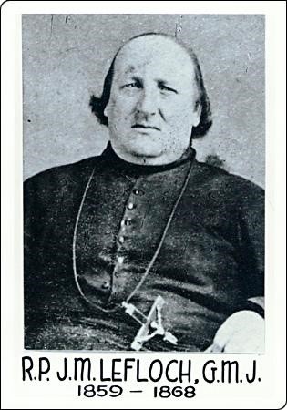
Father Lefloch, the priest from St-Boniface who ministered to the Metis and French settlers at this location, changed the name of the parish to Ste. Anne, a patron Saint in Brittany, France, in 1867. Source: Société historique de Saint-Boniface. Accueil / Au pays de Riel / Lieux / Sainte-Anne / Photos / Jean-Marie Le Floch. Retrieved June 29, 2020 from http://shsb.mb.ca/le-floch Collection générale de la SHSB 9189.
“The early families were headed by Jean Baptiste Perrault dit Morin, François and Charles Nolin, J.B. Sapoint, and August Harrison. In 1861 Taché founded the Mission of St. Alexander at Pointe des Chênes. A chapel was opened in 1866 and a church was built in 1867. Within six months the church was renamed St. Anne because Père Lefloch suggested that St. Alexander would be a more appropriate name for the mission at Fort Alexander. It should be noted that Père Lefloch was a Breton and St. Anne was the patron saint of the Bretons. Metis from this community were the labourers on the construction of Dawson road from Lake of the Woods to Red River. In 1868 John Snow was hired to construct this road. He enraged the residents by ignoring the property boundaries laid out by Roger Goulet for the Council of Assiniboia. Further, he claimed to have bought the land on which they lived from the Saulteaux. The residents evicted Snow and he was charged with two counts of selling liquor (for land) to the Saulteaux at Pointe des Chênes.”
Lawrence Barkwell, author
Source: Barkwell, L. J. (2016). The Metis Homeland: Its Settlements and Communities (P.184). Louis Riel Institute. Rights pending. Retrieved from http://www.metismuseum.ca/resource.php/11956
The parish of Sainte-Anne (des chênes) is located 40 km southeast of Winnipeg. It is nestled on the eastern edge of the Canadian prairies, just west of the boreal forest. The Seine River snakes through the middle of town.
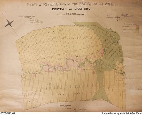
Plan of River Lots in the Parish of Ste. Anne. The river lot of Mr. Olivier Ducharme was Lot #8 on the south side of the river. This is where Boulton’s surveys were told not to put their feet on their land if they wanted to keep their head on their shoulders. This particular lot is today located on the south side of Seine River at the now entrance of Chemin St-Raymond and Hwy. 210. Source: Fonds Corporation archiépiscopale catholique romaine de Saint-Boniface (1874, July) 0075-G11-04. Surveyed by George McPhilipps. SHSB. Retrieved June 24, 2020 from http://shsb.mb.ca/Sainte-Anne/cartes/lots-de-riviere
Go to Next Tour Location: Sainte-Anne-des-Chênes Catholic Church | Top
Previous page: Pioneer Park Exhibit
Next page: Sainte Anne des Chênes Roman Catholic Church