“Historian Arthur J. Ray wrote that many of Canada’s Indigenous people “define themselves in terms of the homelands that sustained their ancestors. These are places where their spiritual roots lie.”
"As recent scholarship has shown, the Metis were “a people on the move.” This does not imply that they were “nomadic” in the sense of randomly moving about without rhyme or reason. On the contrary, they moved with a purpose and their movements were influenced by the waterways, the landscape, the seasons, their means of livelihood, available resources and their alliances and kinship connections with neighbouring Indigenous peoples. If the Metis emerged from marriages à la façon du pays, what shaped them as a people was not so much the genetic make-up of their ancestors as marriage to le pays itself: kinship relations not only within, but with the very territory from which they sprung – or what might be termed a kinscape.
"When Louis Riel sang the praises of the exploits of le peuple Métis canadien-français, he spoke of the “brilliant successes” of his people. What is fascinating about Riel’s account is that the areas and peoples he mentions — the Indians of Minnesota, the Dakota tribes, the mountains and prairies of the Northwest, Regina, Montana, Manitoba — all fall within what is today termed the Metis homeland. What is striking about this area is that it more or less corresponds to waterways of the Lake Winnipeg drainage basin – although the Metis kinscape also extended up into the Mackenzie River basin.”
Darren O’Toole, Metis historian
Source: O’Toole, D. (2017, November 10). Toward a Métis Homeland: As Canada embarks on a process of reconciliation with Indigenous peoples, the Métis are still without territory to call their own. Canadian Geographic. Retrieved June 3, 2020 from https://www.canadiangeographic.ca/article/toward-metis-homeland
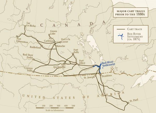
Map of major cart trails in the West prior to the Dawson Trail (note its absence in the bottom right hand corner of Manitoba that would come to link Canada from East to West north of the 49th parallel. Chris Brackley, Canadian Geographic. Source: Indigenous Peoples Atlas of Canada – Royal Canadian Geographical Society (Canadian Geographic). (2020). Red River Carts. Atlas / Métis. Retrieved June 23, 2020 from https://indigenouspeoplesatlasofcanada.ca/article/red-river-carts/
“The Red River Colony, after some challenges in the early part of the century, managed to create a rather peaceful and orderly way to govern over itself following the NWC and HBC merger in 1821. The historical record from this period is clear that the colony, dominated by Métis in numbers, was also a truly multicultural and polyglot community from its beginnings. It thrived and developed relatively peacefully from about 1821 to the early 1860s when the loss of bison and more colonial encroachment started to put severe pressure on their means of making a living and threatening not only their freedom in their own land, but their very existence.”
Mireille Lamontagne, Dawson Trail Heritage Tour researcher
Source: Lamontagne, M. (2020, April). Historiography of the Dawson Trail (P.2). Dawson Arts & Heritage Tour
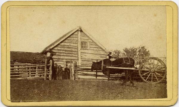
The Métis had their own Michif words for the cart, including aen wagon and aen charet (Marsh, J. H. (2006-2020). Red River Cart. Canadian Encyclopedia, retrieved from Red River Cart. Source: Rice Studio. (1890-1910).) Métis camp with Red River cart / Campement métis et charrette de la rivière Rouge. Library and Archives Canada/Department of the Interior Fonds/c001644. Retrieved June 24, 2020 from collectionscanada.gc.ca/ourl/res.php?url_ver=Z39.88-2004&...
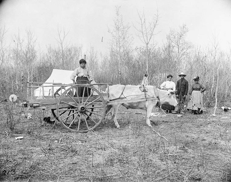
University of Manitoba. (2019). “Early Homestead Building, Family, and Red River Cart Drawn by Ox.” Photographer: Ryder Larsen. Early Homestead Building, Family, and Red River Cart Drawn by Ox. Red River Settlement? Date: [ca. 1869-1870] The size and the relative complexity of the building indicates that homes at this time were not simply crude sod structures. UM Archives. The so-called Red River cart is famously identified with the Métis community and was made entirely without nails or any iron. Retrieved July 1, 2020 from Libraries - Early Homestead Building, Family, and Red River Cart Drawn by Ox
“The quest for a Métis homeland led by Louis Riel caused the creation of Manitoba in 1870, which ended Hudson’s Bay Company control of the land and attempted to control the trade. Soon steamboats and later railroads operated along the Red River and opened the region to new immigrants. However, the Métis were not accepted as Europeans or Native Americans and were shunned, harmed and disenfranchised. Many chose to move west into Saskatchewan and other places where they could live free with their own culture and identity.”
Canadian Geographic
Source: Indigenous Peoples Atlas of Canada – Royal Canadian Geographical Society (Canadian Geographic). (2020). Red River Carts. Atlas / Métis. Retrieved June 23, 2020 from https://indigenouspeoplesatlasofcanada.ca/article/red-river-carts/
Back to Lorette Red River Cart Heritage Tour page | Top
Previous page: Eagle Bus Lines
Next page: Métis Women Entrepreneurs