What is the Dawson Trail?
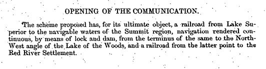
“Opening of the Communication,” from Report on the Line of Route Between Lake Superior and the Red River Settlement by Simon J. Dawson, civil engineer (P.11). House of Commons, Ottawa. Printed by I.B. Taylor at the “Ottawa Citizen” office,1869. Peel Library, University of Alberta. Retrieved from http://peel.library.ualberta.ca/bibliography/481/reader.html#4
Up until the Dawson Trail’s construction, the Red River Colony had prospered but was still cut off from the east by a thousand kilometers of practically impassable country. Considered a planning and engineering feat for its day, the Dawson Trail is celebrated as a “land and water route from Fort William (Thunder Bay) to Red River.” The road portion of the route “was Canada’s first attempt to provide an all-Canadian highway linking the east with the prairies” without having to detour through the United States. Canada had concerns about American annexation of the NorthWest and was dealing with a continuous loss of immigrants to the United States because of how challenging it was to get here from north of the 49th parallel, also known as the Medicine Line. As such, the purpose of the route was to both establish a line of communication with eastern markets in Toronto on the one hand and to act as a direct highway for colonization in one direction and timber in the other until the railroad could be completed. Histories that have been written about the Dawson road generally end here but our research efforts have revealed so much more to this history than the mere building of a road to connect Winnipeg to Toronto in British-held territory.
The lesser known impact of the Dawson Trail, beyond its importance in the early development of communications, transportation and immigration infrastructure in the West, is its connections to Métis Resistance at Red River, its origins as a First Nations trail and to the making of Treaty 3 and Treaty 1, as well as the circumstances around which the region of the Dawson Trail became a sanctuary for French-speaking Catholics in southeastern Manitoba, as well as for Mennonites.
Simon J. Dawson surveyed the route in 1858 for the Canadian Government and explored not only a line for the road but also for the future CPR rail line and an eventual aqueduct. He credits a First Nations Chief whose name he does not mention, that he had “the good fortune” of meeting in the spring of 1859, for showing him the high ground on which the country could be crossed. To some, Dawson was perceived as a sympathizer to the causes of Indigenous Peoples and French-speaking Catholics. When construction of the road was completed in 1871 and John Snow, the road’s Superintendent, had long since been made to leave the colony for his lawlessness, mistreatment of the workers, and disdain for Métis and First Nations, Simon Dawson went on to play, along with Bishop Provencher and other peacemakers, a key role in the making of Treaty 3 at the NorthWest Angle with Anishinaabe (Saulteaux, Ojibwe) in defense of their rights. Treaty 3 then served as the model for future numbered treaties across the prairies.
In 1870, just after Manitoba entered Confederation as the postage-stamp province and Colonel Wolseley and his troops were dispatched from Toronto to the Red River Colony to disband its provisional government under Louis Riel to install a new government, they struggled to find a way through the dense bush and muskegs. Two French-Canadian settlers from Ste. Anne, Manitoba eventually guided them through and by 1871 a corduroy road from the NorthWest Angle of the Lake of the Woods to Fort Garry (Winnipeg) was opened to travel. What happened in those years would come to change the North-West forever after and it is those stories we are highlighting in this resource for you to discover.
When complete, the road may not have been an impressive sight, but it saw its first 300 settlers by 1874. With improved services in 1875, including a stagecoach three times a week, Dawson’s road brought another 2700 settlers to the west by 1878, many of them military officers who were part of the Red River Expeditions. The rail line was completed to Selkirk by 1878 and from that point forward, the water route and the station at the NorthWest Angle went slowly into disuse over the next decades, except perhaps by local populations and by those who were either more adventurous travellers or could not afford the cost of rail and steamboat travel. Today, the water route to the NorthWest Angle on Lake of the Woods can only be accessed by canoe or winter trails having been replaced by the Trans-Canada Highway (#1) for vehicular travel in the 1960s, a route which veered further north than the Dawson through Kenora, Ontario (formerly Rat Portage), which also served as the hub for the construction of the C.P.R rail line from the east, drawn earlier by Dawson. Many First Nations and Métis who built or hauled on the Dawson Road also worked on either hauling materials for the railroad or building the railroad at Rat Portage using the Dawson Trail as the artery through which supplies and provisions were moved for the camps.
As we mark the 150th anniversary of Manitoba, the heart of the Dawson Trail still beats strong in the communities of Richer, Sainte-Anne and Lorette. We invite Manitobans, Canadians, travellers, vacationers and newcomers alike to explore and reflect on this history through a tour of the treasures of the Dawson Trail. You will be welcomed in our communities with the same warmth and generosity that became the trademark of the Dawson Trail so long ago. The Dawson Trail Arts and Heritage Tour committee is pleased to be reviving its memory and stories through this community arts and heritage initiative.
Enjoy the discoveries!
Sources:
Winnipeg Free Press. “The Dawson Route” by Margaret Arnett McLeod, August 3, 1940. Retrieved from https://newspaperarchive.com/browse/ca/mb/winnipeg/winnipeg-free-press/1940/aug-03-p-29/
Manitoba Historical Society. Historic Sites of Manitoba: Dawson Road Monument...
Report on the Line of Route Between Lake Superior and the Red River Settlement by Simon J. Dawson, civil engineer (P.11). House of Commons, Ottawa. Printed by I.B. Taylor at the “Ottawa Citizen” office,1869. Peel Library, University of Alberta. Retrieved from http://peel.library.ualberta.ca/bibliography/481/reader.html#4
Wallace, W.S. ed. (1948). The Encyclopedia of Canada (P.187). Vol. II. Toronto: University Associates of Canada, 411p. Retrieved from Dawson route - Dawson road
Arthur, E. (1994). DAWSON, SIMON JAMES. Canadian Dictionary of Biography, vol 13. University of Toronto/Université Laval. Retrieved June 10, 2020, http://www.biographi.ca/en/bio/dawson_simon_james_13F.html
Dawson, S.J. (1869). [Map] Shewing Line of Route Between Lake Superior to the Red River Settlement as drawn by S.J. Dawson and A.L. Russell. Retrieved fromhttps://commons.wikimedia.org/wiki/...or the original source https://www.flickr.com/photos/manitobamaps/3716493151/#/
Dawson, S.J. (1868) Report on the Line of Route Between Lake Superior and the Red River Settlement (P.9). House of Commons, Ottawa. Printed by I.B. Taylor at the “Ottawa Citizen” office,1869. Peel Library, University of Alberta. Retrieved June 10, 2020 from http://peel.library.ualberta.ca/bibliography/481.html
Arthur, E. (1994). DAWSON, SIMON JAMES. Canadian Dictionary of Biography, vol 13. University of Toronto/Université Laval. Retrieved June 10, 2020, http://www.biographi.ca/en/bio/dawson_simon_james_13F.html
Bowsfield, H. (2004). SNOW, JOHN ALLAN. Dictionary of Canadian Biography, vol. 11, University of Toronto/Université Laval. Retrieved June 11, 2020, http://www.biographi.ca/en/bio/snow_john_allan_11E.html
Arthur, E. (1994). DAWSON, SIMON JAMES. Canadian Dictionary of Biography, vol 13, University of Toronto/Université Laval. Retrieved June 10, 2020, http://www.biographi.ca/en/bio/dawson_simon_james_13F.html
Feilberg, E., & Annell, L. (1989). Pioneer History of Glenn, East Braintree & McMunn (p.17). Retrieved from http://hdl.handle.net/10719/2239350
.jpg)
Next: Dawson Route Distances | Top
Previous page: Home
Next page: Dawson Route Distances