Exploration of the Country Between Lake Superior and the Red River Settlement (P.21) by Canada, Provincial Secretary’s Office, George Gladman, Simon James Dawson, Henry Youle Hind. Publisher: G.E. Eyre and W. Spottiswoode, 1859. Harvard University. Retrieved from https://books.google.ca/books?id=F_AtAAAAYAAJ&pg=PA52&lpg=PA52&dq=Simon+Dawson+exploratory+line
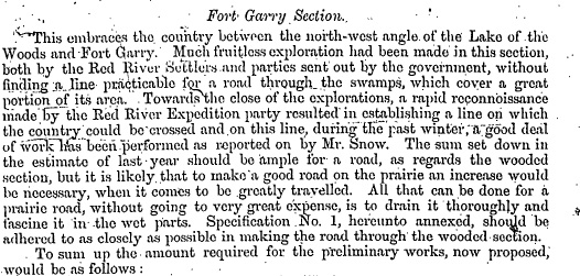
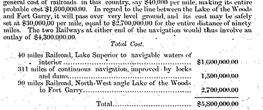
Original Cost Estimate for Dawson Route by Simon J. Dawson. Summary of the Report on the Line of Route Between Lake Superior and the Red River Settlement (P.25) by Simon J. Dawson, civil engineer. House of Commons. Ottawa. Printed by I.B. Taylor at the “Ottawa Citizen” office (1869). Peel Library, University of Alberta. Retrieved from http://peel.library.ualberta.ca/bibliography/481/reader.html#4
Next: Historic Maps of Dawson Trail | Top
Previous page: Dawson Trail: Symbol of Togetherness
Next page: Historic Maps of Dawson Trail