“Corduroy road” is the name given to the type of road construction that was used to stabilize roads through the muskeg country of eastern Manitoba. This method of construction was applied on the early Dawson Road which was built over rivers, swamps and marshes across a terrain that transitioned from boreal forest through meadows into the beginning of the Canadian prairies.
The building of corduroy roads consists of felling trees and laying the logs side by side across the swamp, which the Métis workers called “maskègues” (muskegs). It was a practical method for the time, especially when one thinks of the famous Caribou Muskeg, some five kilometers east of the Birch River, which was so deep that a 12-foot pole could not reach the bottom of the swamp. As travel increased on the road, the logs would begin to settle and twist every which way, making travel a bone-jarring experience for travelers and newcomers. The roads were so bad that most people preferred horseback or walking rather than by cart or wagon.
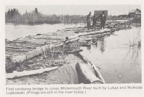
First corduroy bridge to cross the Whitemouth River in Manitoba along the Dawson Road circa early 1870 built by Lukaz and Nicklas Lupkowski. In 1989, there were still pilings in the river. Hadashville Women's Institute. (1970). A Packsack of Seven Decades (P.63). Derksen Printers. Retrieved from the digital collections of the University of Manitoba, June 3, 2020 from http://hdl.handle.net/10719/3066498 or https://digitalcollections.lib.umanitoba.ca/islandora/object/uofm%3A3066415#page/63/mode/2up
"As more settlers arrived, trails were blazed through tree country. The era of the horse and buggy had arrived. To cross the rivers, rafts were made and later boats were used. Credit is due to Peter Medynski, who in time of emergency to reach a midwife, built a bridge of round poles. In 1914, a corduroy bridge was built just south of Kipling School by Joseph Lupkowski and son. This bridge served the settlers of Hadashville until 1922. The Samec bridge, built by J. Samec and neighbours in the winter of 1919 in rebuilt form, was used until 1969."
Hadashville Women’s Institute, 1970
Source: Hadashville Women's Institute. (1970). “Trails, Roads and Bridges.” A Packsack of Seven Decades. Chapter 14 (P.59). Derksen Printers. Retrieved from the digital collections of the University of Manitoba, June 3, 2020 http://hdl.handle.net/10719/3066498
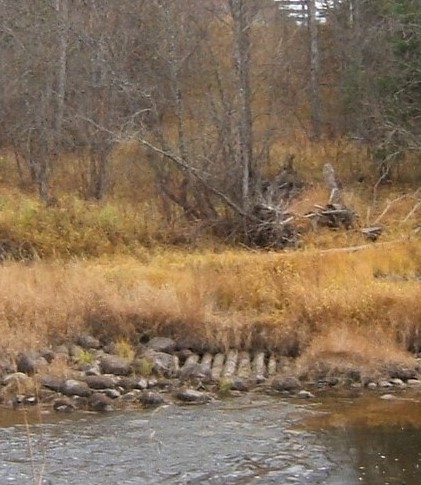
What remained of the Whitemouth River Bridge on Dawson Road. The bridge was destroyed by flood in the 1930’s and never rebuilt. This image was taken near the property of Mr. & Mrs. George Lavack (Photo 2014) Courtesy Norm Lavack.
Report on the Line of Route Between Lake Superior and the Red River Settlement by Simon J. Dawson, civil engineer (P.21). Printed by order for the House of Commons. Ottawa. Printed by I.B. Taylor at the “Ottawa Citizen” office1869. Peel Library, University of Alberta. Retrieved April 30, 2020 from http://peel.library.ualberta.ca/bibliography/481/reader.html#25
Back to Dawson Trail Park Heritage Tour Page | Top
Previous page: The Lost Treasure
Next page: The Caribou Bog