POINT OF INTEREST: Commemorative Marker #8
Acknowledgement of Ancestral Lands
HISTORICAL NUGGETS: Bison Hunting
Majestic Beaver Dam (Mistamiscano) | Of Mud and Straw
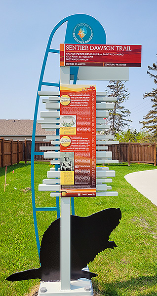 Commemorative Marker #8
SEE GOOGLE MAP LOCATION
Theme: Grande Pointe-des-chênes / Anishnaabe Chief
Just east of Finnigan Road along the Dawson Trail, you will see the next marker on the south side.
We recommend turning into Seine River Crossing Road and parking in the residential area to walk to the marker along the walkway as the road is quite busy in this area.
Once finished your visit, continue eastward along the Dawson Trail #207.
Acknowledgement of Ancestral Lands
While Métis were quite miraculously able to negotiate the enshrining of their pre-existing rights and title to land into the Manitoba Act, and First Nations of the region into Treaties Number 1 and 3 as the original inhabitants of this part of Manitoba, ultimately both Métis and First Nations experienced severe loss in these years. Shortly after Manitoba entered Confederation began the era of the Reign of Terror, the Indian Act, Reserves and the Residential Schools system.
The Dawson Trail itself and the communities that have grown around it over the last centuries lie on the ancestral lands of the Métis, Anishinaabe (Saulteaux, Ojibwe), Nêhiyawâk (Plains Cree), Nakota (Assiniboine), and Dakota peoples who have lived from these lands since time immemorial.
It is critical to recognize the direct role the Dawson Road played in the history of colonization in western Canada as a ‘colonization road’ and to acknowledge the damage that our shared history has had on Indigenous Peoples in this country. This educational resource revisits the subject of the Dawson Trail in the spirit of truth and reconciliation.
As we celebrate 150 years of the Dawson Trail in Manitoba, we ask our visitors to participate actively in responding to the 94 Calls to Action on truth and reconciliation and to reflect on what each and every one of us might do to repair these relationships going forward.
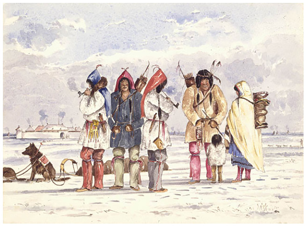
Sauteaux (Saulteaux) Anishinaabe First Nation family (rabbit skin dresses) opposite Fort Garry, ca. 1857-8 by William Napier. Library and Archives Canada/Reminiscences of North America/c146728k. Retrieved from Saulteaux Indians, Fort Garry, ca. 1857-1858, by William Napier - The Canadian West - Exhibitions - Library and Archives Canada
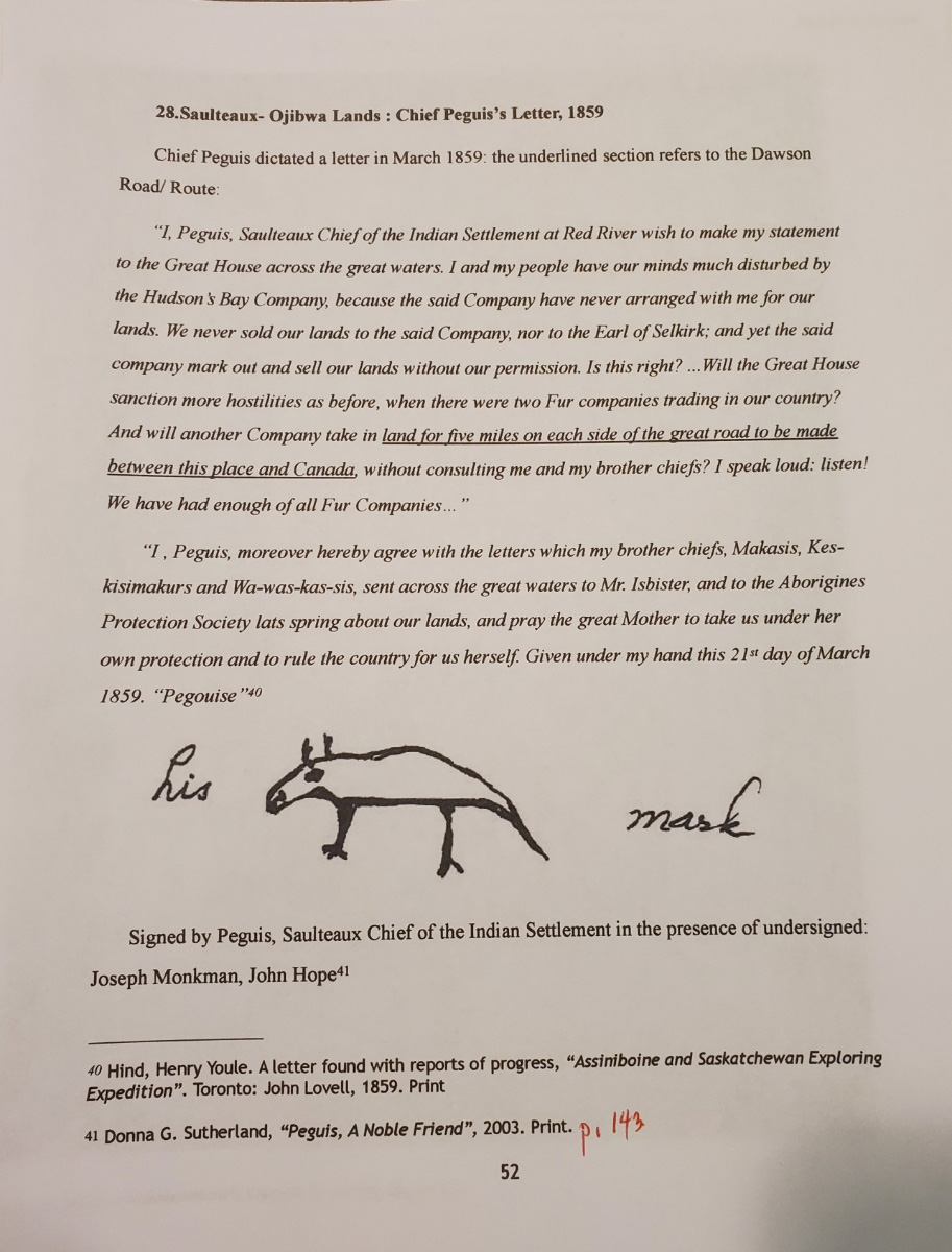
“And will another Company take in land for five miles on each side of the great road to be made between this place and Canada without consulting me and my brother chiefs? I speak loud! listen!” are the words of Chief Peguis in this letter to London (the ‘Crown’) concerning the future construction of Dawson Road. Source: Sutherland, Donna. (2003). Peguis: A Noble Friend (P.143). Published by Chief Peguis Heritage Park Inc. Print.
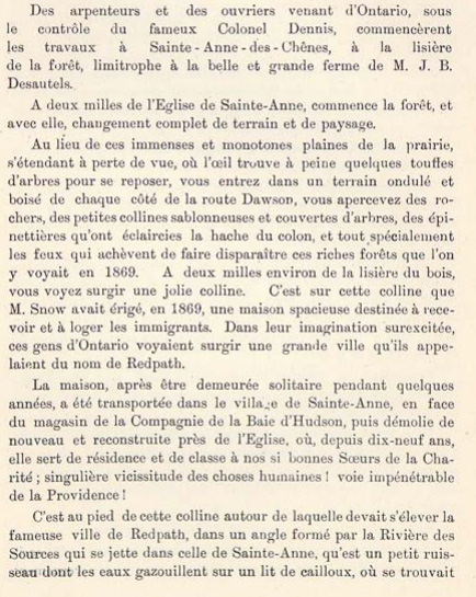
A ‘History of Dawson Road and its importance for Sainte-Anne-des-Chênes’ by an anonymous member of the Société historique de Saint-Boniface in Les cloches de Saint-Boniface, 1902 reflecting on Dawson Road in 1869 and its connection to the Red River Resistance. Archives of the Société historique de Saint-Boniface. Retrieved June 4, 2020 from https://shsb.mb.ca/chemin-dawson. Les cloches de Saint-Boniface, Vol. 1, No. 14, 15 oct. 1902, P.352-356.
It is at the foot of this hill around which the famous town of Redpath was to rise, in an angle formed by the Rivière des Sources which flows into that of Sainte-Anne, that is a small stream whose waters babble on a bed of pebbles, where there was …[a First Nations] cemetery. For long before the settlement of Sainte-Anne, …[First Nations] came to pitch their tents there and lived from hunting, which was very abundant at the time. When the Federal Government had established schools on (...) reserves, one of the(m) (...) responded to one of the parishioners of Sainte-Anne's who urged him (an old man) to settle on the reserves:
He said: "What do you want? It is hard for us to leave the place where we were born, the place where our ancestors are buried. Everywhere else I'm bored, and like the bird that loves to return to where it made its nest, also my heart is only happy when I raise my head near the edge of the woods."
This is the same old Indian who was responding to the parish priest of St. Anne's who was preparing him for baptism:
"He said: "I can't understand why all men are descended from the same father and mother, given the diversity of languages."
It wasn't until the priest explained the confusion of God's tongues that he answered:
He responded: "Then I understand, and I believe that whites and Indians all have the same origin." (translated)
Anonymous Member of the Société historique de Saint-Boniface, 1902
in Les cloches de Saint-Boniface
Source: A ‘History of Dawson Road and its importance for Sainte-Anne-des-Chênes’ by an Anonymous Member of the Société historique de Saint-Boniface in Les cloches de Saint-Boniface 1902 reflecting on Dawson Road in 1869 and its connection to the Red River Resistance. Archives of the Société historique de Saint-Boniface. Retrieved June 4, 2020 from https://shsb.mb.ca/chemin-dawson.
Go to Next Tour Location: Where the Forest Meets the Western Prairies | Top
Previous page: Old Finnigan Bridge / Old HBC Post
Next page: Where the Forest Meets the Western Prairies