HISTORICAL NUGGETS CONNECTED WITH THIS LOCATION:
Troubles at the Red River Colony: Surveying Gives Rise to Tensions
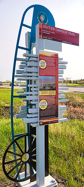 Commemorative Marker #14
SEE GOOGLE MAP LOCATION 
Theme: "Scrub Bog" / "Pig Ridge" / "Gaudet's Road"
This commemorative marker is located on the south-east corner of Fermor Ave. and Lagimodiere Boulevard, which is across the boulevard from the Royal Canadian Mint.
The marker is located along walking paths and there is no parking along either Lagimodiere Blvd. or Fermor Ave.
To access the marker, go east 230 metres on Fermor Ave. to Royal Mint Drive and south to the paved walking path, park in the residential area and walk westward along the walking path to the marker.
Up until the Dawson Trail’s construction, the Red River Colony had prospered but was still cut off from the east by a thousand kilometers of practically impassable country. Considered a planning and engineering feat for its day, the Dawson Trail is celebrated as a “land and water route from Fort William (Thunder Bay) to Red River.” The road portion of the route “was Canada’s first attempt to provide an all-Canadian highway linking the east with the prairies” without having to detour through the United States. Canada had concerns about American annexation of the NorthWest and was dealing with a continuous loss of immigrants to the United States because of how challenging it was to get here from north of the 49th parallel, also known as the Medicine Line. As such, the purpose of the route was to both establish a line of communication with eastern markets in Toronto on the one hand and to act as a direct highway for colonization in one direction and timber in the other until the railroad could be completed. Histories that have been written about the Dawson road generally end here but our research efforts have revealed so much more to this history than the mere building of a road to connect Winnipeg to Toronto in British-held territory.
The lesser known impact of the Dawson Trail, beyond its importance in the early development of communications, transportation and immigration infrastructure in the West, is its connections to Métis Resistance at Red River, its origins as a First Nations trail and to the making of Treaty 3 and Treaty 1, as well as the circumstances around which the region of the Dawson Trail became a sanctuary for French-speaking Catholics in southeastern Manitoba, as well as for Mennonites.
Traffic on the Dawson Road
“The Dawson Road was named for S.J. Dawson who surveyed it. Originally a …[First Nations] Trail, it was the only vein of transportation between the [Red River] Settlement and LaBroquerie and Marchand, and took the traveller through Prairie Grove. It must have been a picturesque sight to see the Métis trains of homemade sleds, constructed of wood and leather and drawn by teams of oxen. Sometimes it was hot and dry with no water for man or beast.
"Through the efforts of Bishop Taché, a well was dug on the bald prairie with no shelter for miles around. It filled a need for many years. Each Métis train consisted of thirteen or fourteen sleds. They would set up camp at night and when they were near the McQuade farm they found it very convenient to build their fire with the rails from Henry's fence. He replaced it many times, but it finally had to be abandoned, not without at least one attempt to frighten them away. Henry put gunpowder in a hollow rail. "Fate stepped in." A heavy rain wet the powder making it ineffective. "The plot was foiled". 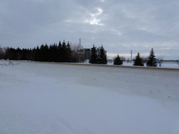
"Today the Dawson Road is a much travelled first class highway, carrying produce of farm and forest to the city, and merchandise, etc. to the large populated areas south and east of Winnipeg.”
Dugald Women’s Institute, 1974
Dawson Road through Prairie Grove heading East (December, 2019). Note that when Hwy#1 (Trans-Canada) and the Winnipeg Floodway were built in the 1960s, the Dawson Trail, as well as the town of Prairie Grove, were cut off from the flow of commercial traffic they once had. To find it, follow Hwy#1 East to Deacon’s corner, turn right as though heading to Lorette until you see the sign for Prairie Grove. Photo credit: Mireille Lamontagne.
Source: Dugald Women’s Institute. (1974). Springfield: 1st Rural Municipality in Manitoba 1873-1973 (P. 348). Printed by D.W. Friesen & Sons Ltd.: Altona. Retrieved June 22, 20120 from http://www.mb1870.org/localhistory/007%20-%20Dugald%20Women's%20Institute,%20Springfield%20-%201st.pdf
Jean-Baptiste Lagimodière
Lagimodiere Boulevard was named after Jean-Baptiste Lagimodière (born 25 December 1778 in Trois-Rivières, Quebec – 7 September 1855 in Saint-Boniface, Manitoba), who was a French-Canadian trapper employed in the fur trade by the Hudson's Bay Company in Rupert's Land.
Lagimodière is noted both as the grandfather of Métis leader Louis Riel, and as the husband of Marie-Anne Gaboury, the first woman of European descent to travel to and settle in western Canada. The Lagimodières were also, in 1812, the first settlers at the Red River Colony near modern Winnipeg, Manitoba.
Source: https://en.wikipedia.org/wiki/Jean-Baptiste_Lagimodi%C3%A8re
Go to Next Tour Location: Prairie Grove | Top
Previous page: Saint-Boniface
Next page: Prairie Grove