The Dawson Trail started as a road heading northwest from Port Arthur along the Shebandowan River, up to Shebandowan Lake. From there, the trail followed a series of lakes and rivers heading west, eventually ending up at the Rainy River and Lake of the Woods along the International Boundary. After crossing Lake of the Woods, the road continued for approximately 10 miles (16 kilometres) through the U.S. at Northwest Angle, overland back into Canada to Richer, Manitoba and then to its end at St. Boniface.
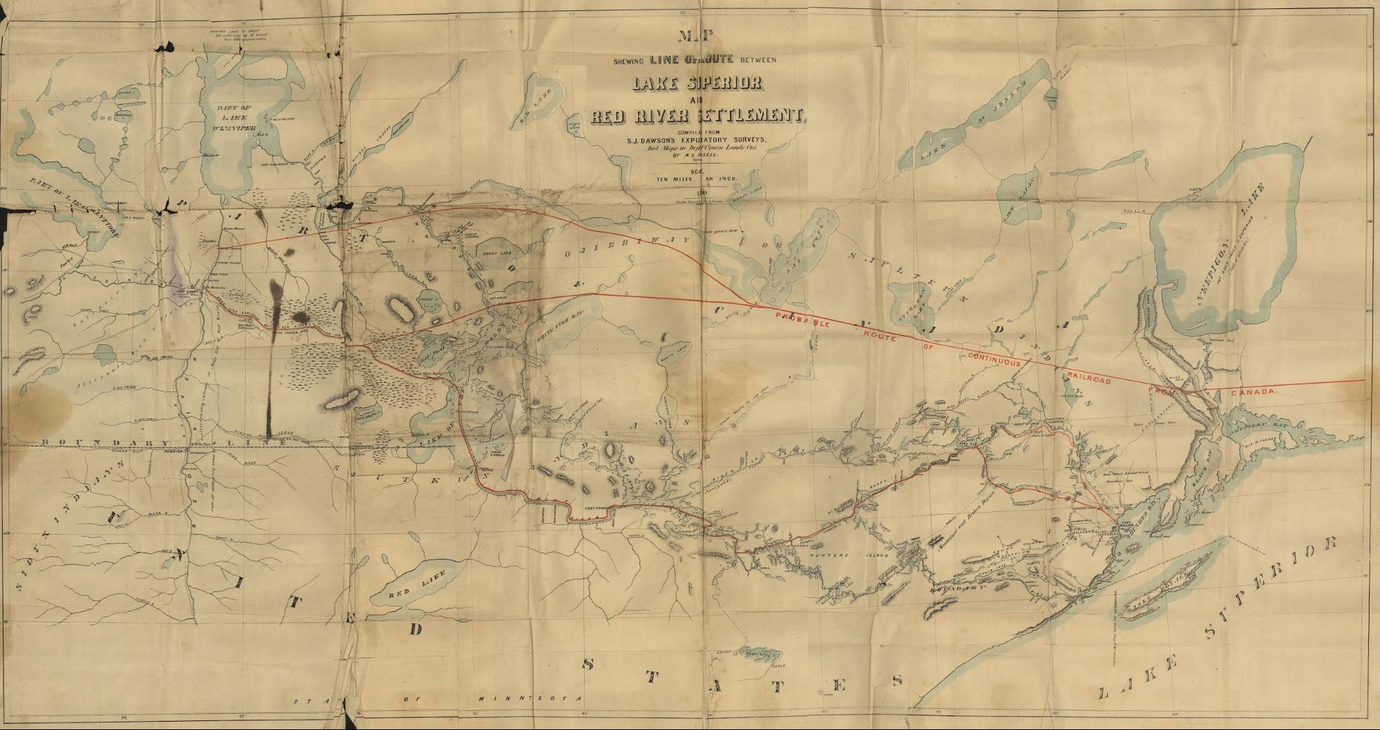
Dawson, S.J. (1869). [Map] Shewing Line of Route Between Lake Superior to the Red River Settlement as drawn by S.J. Dawson and A.L. Russell. Retrieved from https://commons.wikimedia.org/wiki/File:Map_Shewing_Line_of_Route_Between_Lake_Superior_and_
Red_River_Settlement_(1869).jpg or the original source https://www.flickr.com/photos/manitobamaps/3716493151/#/
The seeds for the idea of what became the Dawson Route connecting East to West were planted by the 1850s as the gaze of politicians and business people in the East turned West for its riches beyond the fur trade which was already on the decline. They sent several exploring expeditions to the region between Lake Superior and Red River in this period, such as the Palliser (1857) and Hind & Dawson Expeditions (1858-59) to ascertain both what those riches were and how they could be accessed with the development of infrastructure.
Their idea had long been to construct a railroad straight West through British Territory (it wasn’t Sir John A. McDonald’s idea though he did make it the hallmark of his political campaign) but the rock, water, swamp and muskeg terrain in between made for a formidable obstacle. As more reports came back to share information on the bounty that laid beyond, survey parties and settlers increasingly made their way west. There were several disputes during this period between the political regimes of the north (which was British territory) and the USA about where the international boundary would lie in this complex geo-political zone.
Sources:
Boundary Trail National Heritage Region (n.d.). “Mounties, Scientists & Surveyors – Expeditions, 1857-1874”. Explore Our Heritage. Retrieved June 21 from http://www.bthr.ca/explore-our-heritage-3/
Dawson, S. J. (1868). Report on the line of route between Lake Superior and the Red River Settlement (P.22). House of Commons. Hunter, Rose & Company: Ottawa. Also published by I.B. Taylor, 1869: Ottawa. Retrieved June 3, 2020 from http://peel.library.ualberta.ca/bibliography/481.html. For French version see Rapport sur le trace de la route entre le lac Supérieur et l’établissement de la Rivière-Rouge. Ottawa : Hunter, Rose et Lemieux, 1868, retrieved June 3, 2020 from http://peel.library.ualberta.ca/bibliography/480.html
Wikipedia contributors. (2020, June 15). Old Dawson Trail. In Wikipedia, The Free Encyclopedia. Retrieved 19:25, June 21, 2020, from https://en.wikipedia.org/w/index.php?title=Old_Dawson_Trail&oldid=962602581
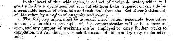
“A tract of navigable water…quagmire and swamp” from Report on the Line of Country between Lake Superior and the Red River Settlement, and Between the Latter Place and Saskatchewan and Assiniboine, (P.22) by Simon J. Dawson, civil engineer. House of Commons: Ottawa. Printed by I.B. Taylor at the “Ottawa Citizen” office (1869), Peel Library, University of Alberta. Retrieved June 4, 2020 from http://peel.library.ualberta.ca/bibliography/481/reader.html#25
Water Route (Ontario to Manitoba)
After traversing a long string of lakes and rivers along the old canoe route in the precambrian shield country of the boreal forest and undertaking up to 70 portages along the way, travellers of the Dawson Route in the late 1800s were greeted by a steamer to take them across the Lake of the Woods to the landing at the Northwest Angle where the road began.
Various sources
Source: Wikipedia contributors. (2020, June 15). Old Dawson Trail. In Wikipedia, The Free Encyclopedia. Retrieved 19:25, June 21, 2020, from https://en.wikipedia.org/w/index.php?title=Old_Dawson_Trail&oldid=962602581
*For a complete listing of the lakes and rivers crossed from Thunder Bay to the NorthWest Angle along what came to be known as the Dawson Route, refer to the Table of Distances.
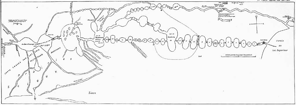
LaVérendrye, an early European explorer to this region drew this version of the journey from Lake Superior to Lake of the Woods based on the knowledge of Indigenous people (likely Anishinaabe/Saulteaux/Ojibwa) that he met circa 1740s in the Great Lakes country. LaVérendrye established Fort St. Charles on Lake of the Woods, not far from where immigrants to Manitoba 150 years later would encounter the NorthWest Angle of the Dawson Road. Retrieved from France National Archives via Library and Archives Canada, http://epe.lac-bac.gc.ca/100/206/301/lac-bac/explorers/data2.collectionscanada.gc.ca/ap/c/c016133.jpg
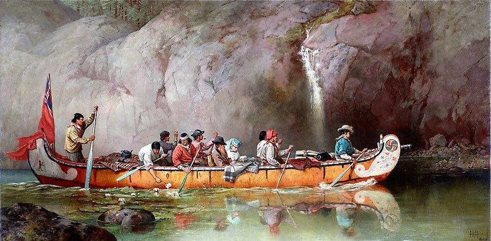
“Canoe manned by voyageurs passing a waterfall” by Frances Anne Hopkins (1838-1919) in 1869. Library and Archives Canada/Frances Anne Hopkins fonds/e011153912, C-002771, MIKAN 2894967 Retrieved March 1, 2020 from File:Canoe Manned by Voyageurs Passing a Waterfall.jpg
Height of Land Portage
Height of Land Portage is a portage along the historic Boundary Waters route between Canada and the United States. Located at the border of the Canadian province of Ontario and the U.S. state of Minnesota, the path is a relatively easy crossing of the Laurentian Divide separating the watersheds of the Atlantic and Arctic oceans.
The portage was used for centuries by indigenous peoples for canoe travel, teaching it to European voyageurs and coureurs des bois who used it to access the fur trading posts in Rupert's Land. For many years the portage was part of an important route from Lower Canada to the interior of the North American continent. It became part of the boundary between British North America and the United States following the American Revolution and treaties delineating the border. In recognition of this history, the portage is on the U.S. National Register of Historic Places, and is a Minnesota State Historic Site.[2]
Located in La Verendrye Provincial Park and the Boundary Waters Canoe Area Wilderness in the unspoiled country along the international boundary, the portage retains its traditional use, but for recreational canoe trips rather than commerce.
Voyageurs coming for the first time to the pays d'en haut were “initiated” after crossing the portage. Each newcomer would be sprinkled with a cedar bough dipped in water, and be made to swear that he would not allow another novice to pass that way without undergoing similar rites and that he would never kiss another voyageur's wife without her consent. Concluding the ceremony with a gunfire salute and drinks of "high wine" (a type of rum), the new Homme du nord or Nor'wester and his company would resume their journey.[12][13]
Wikipedia contributors. (2020, January 11). Height of Land Portage. In Wikipedia, The Free Encyclopedia. Retrieved 20:45, June 21, 2020, from https://en.wikipedia.org/w/index.php?title=Height_of_Land_Portage&oldid=935260266
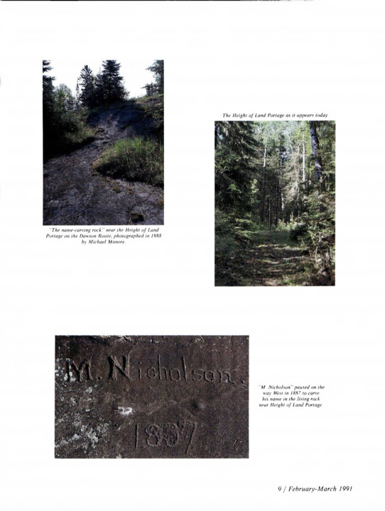
Images are photographed by Michael Manore and reproduced from the February-March 1991 edition of The Beaver magazine, “Mr. Dawson’s” Road by Jack Manore. P.9. Retrieved from https://canadashistory.partica.online/canadas-history/the-beaver-feb-mar-1991/flipbook/8/. Captions read as follows: Top left image: “The name-carving rock” near the Height of Land Portage on the Dawson Route, photographed 1988 by Michael Manore. [Note that the “Height of Land Portage is just before Lac des milles lacs on the way to Lake of the Woods]. Middle right image: The Height of Land Portage as it appears today [1991]. Bottom image: “M. Nicholson” paused on the way West in 1887 to carve his name in the living rock near the Height of Land Portage.. Height of Land Portage is a portage along the historic Boundary Waters route between Canada and the United States. Located at the border of the Canadian province of Ontario and the U.S. state of Minnesota, the path is a relatively easy crossing of the Laurentian Divide separating the watersheds of the Atlantic and Arctic oceans.
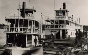
Itaska and Agwinde, two steamers that operated on Rainy River and Lake of the Woods, 1890. Source: Kiinawin Kawindamowan. “Episode 19: Into Lake of the Woods.” University of Toronto. Retrieved from Episode 19: Into the Lake of the Woods - Kiinawin Kawindomowin
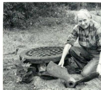
Renowned fur trade historian, Dr. Grace Lee Nute finds relics from one of Dawsons’ steam tugs that would take emigrants across the Lake of the Woods to the NorthWest Angle. The Beaver magazine, winter 1954, P. 19. Retrieved from https://canadashistory.partica.online/canadas-history/the-beaver-winter-1954/flipbook/18/
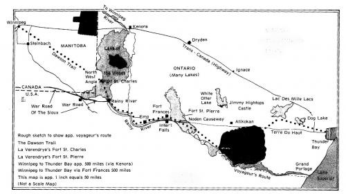
Map showing LaVérendrye’s trail, a trail used by First Nations long before him and voyageurs and emigrants after him. Note where this old trail met up with Dawson Road at the NorthWest Angle of the Lake of the Woods. The Dawson Route travelled by newcomers and by Canadian military and police forces, used a combination of canoe, steamboat and red river cart to make the journey to Winnipeg from Thunder Bay. Courtesy Lake of the Woods Museum. Retrieved from: Lake of the Woods, Lac Du Bois | Morson Tourism
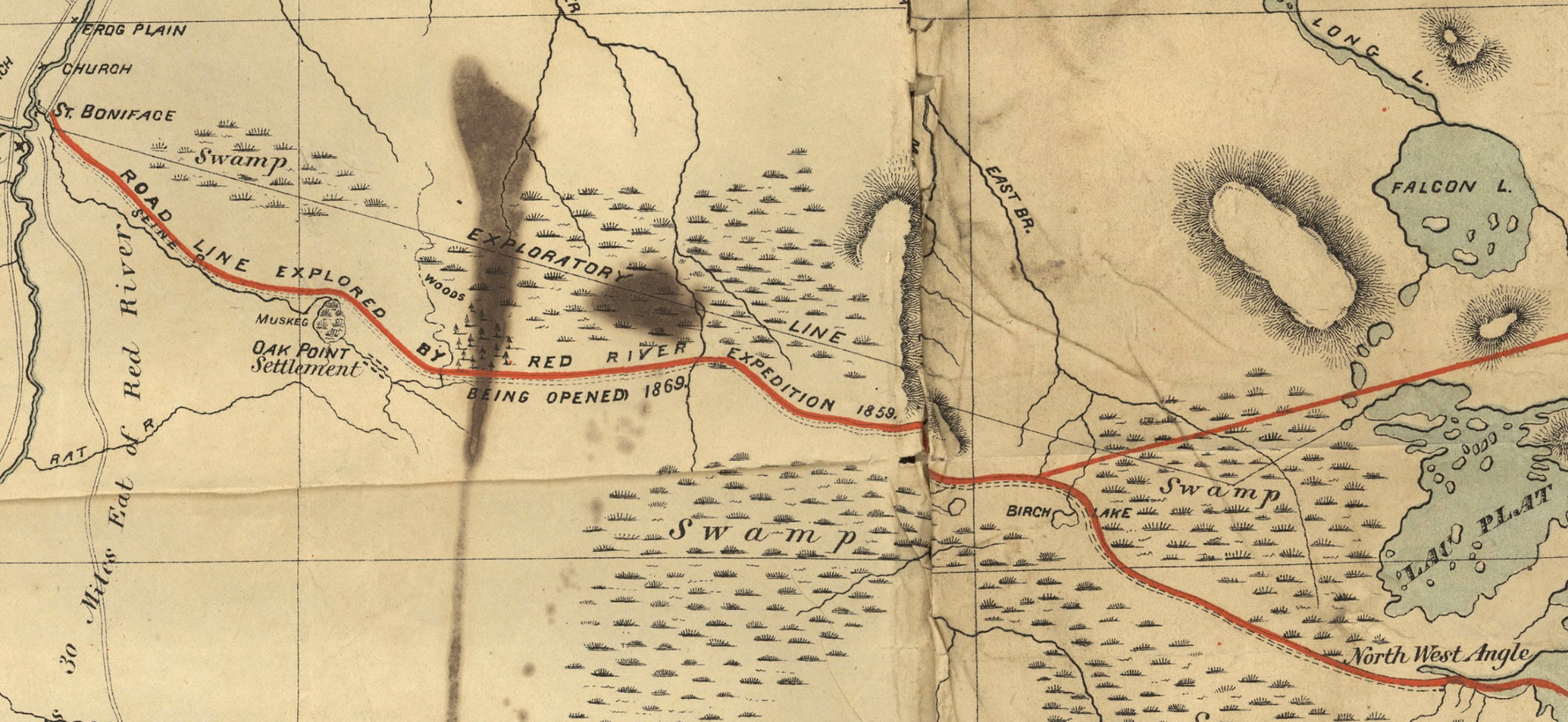
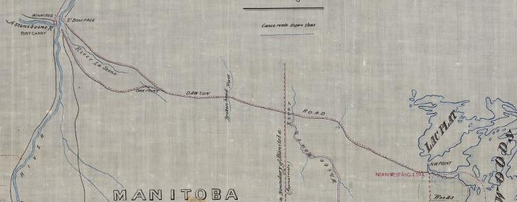
Land Route (Manitoba)
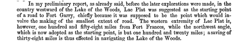
In Dawson's preliminary report on the line of route he had initially suggested that the road access start at Lac Plat (today known as Shoal Lake) because of its shorter distance to Fort Garry (now Winnipeg) overland than from the NorthWest Angle. However when costs started to become prohibitive, the access point was changed to the NorthWest Angle because it saved thirty-eight miles of navigation on water from From Frances.
Dawson, S. J. (1868). Report on the line of route between Lake Superior and the Red River Settlement (P.18). House of Commons. Hunter, Rose & Company: Ottawa. Also published by I.B. Taylor, 1869 (32p): Ottawa. Retrieved June 3, 2020 from Peel 481: Dawson, Simon James, Report on the line of route between Lake Superior and the Red River Settlement (1868). For French version see Rapport sur le trace de la route entre le lac Supérieur et l’établissement de la Rivière-Rouge. Ottawa : Hunter, Rose et Lemieux, 1868, retrieved June 3, 2020 from http://peel.library.ualberta.ca/bibliography/480.html
Map of Dawson Road portion of Simon J. Dawson’s Route from Lake Superior to the Red River Settlement as drawn by S.J. Dawson and A.L. Russell (1869). Note Dawson’s notation of his previous 1858 explorations with the Hind Expedition. Retrieved from https://commons.wikimedia.org/wiki/File:Map_Shewing_Line_of_Route_Between_Lake_Superior_and_Red_River_Settlement_(1869).jpg or the original source https://www.flickr.com/photos/manitobamaps/3716493151/#/
The road from the Northwest angle to Ste. Anne passed through a tamarack swamp, bog and muskeg interspersed with cedar, spruce and firs, for about 112 kms west from the angle, necessitating, with few exceptions, the construction of corduroy over the entire distance. In that initial 112 kms (70 miles) were also three dangerous river crossings at Birch River, Whitemouth River and Brokenhead River. Here the soil becomes more sandy and gravelly for eight or ten miles, covered with scrubby oaks, poplar and a few conifers up to Ste. Anne, which is within about 50 kms (30 miles) of Winnipeg. Once the open prairie was met, the soil changed into a black loam, deep and rich, covered with prairie grass and small groves of young poplars. '
Close up of Dawson Road on George Dawson's map of the canoe journey he made from Lake of the Woods, Ont., to Dufferin, Man., in 1873. (Map credit: Sketch Map showing Indian Canoe route explored by Mr. G.M. Dawson Geologist H.M.N.A.B.C., 1873, G.M. Dawson, Library and Archives Canada/Maps, plans and charts/e011161386. George Dawson (no relation to Simon J. Dawson who engineered the Dawson Route) worked on the North American Boundary Commission surveying the international boundary. Note his depiction of the Dawson route with a south and north branch beginning around Ste. Anne on either side of the Seine River. Retrieved from https://www.canadiangeographic.ca/article/beyond-boundary

“90 miles over ground,” from Report on the Line of Route Between Lake Superior and the Red River Settlement by Simon J. Dawson, civil engineer (P.11). Printed by order for the House of Commons. Ottawa. Printed by I.B. Taylor at the “Ottawa Citizen” office1869. Peel Library, University of Alberta. Retrieved from http://peel.library.ualberta.ca/bibliography/481/reader.html#4
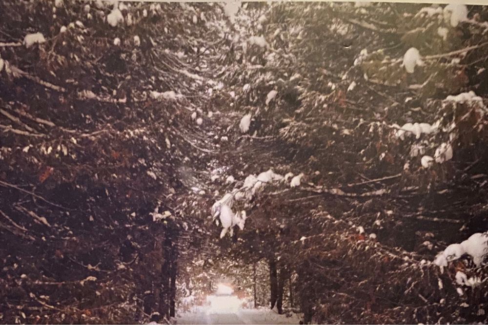
Canopy forming a tunnel over the Dawson Trail near the NW Angle in the winter (ca. 1993). Photo credit: Roger Godard
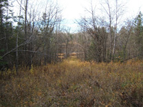
Vestiges of the Dawson Trail still exist. This is an example where the trail is overgrown but still perceptible on the East side of the Whitemouth River (2014). Photo courtesy: Norm Lavack
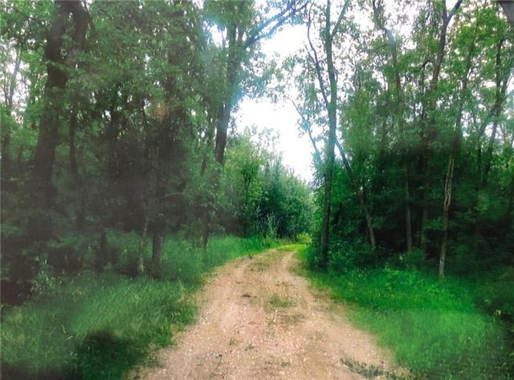
Property along the Dawson Road today east of Richer, Manitoba near Sandilands Provincial Forest (2020). Winnipeg Free Press Homes. Retrieved June 10, 2020 from 0 Dawson Road, R0E 1S0 for sale Rural Manitoba, R06
Next: Commemorating the Dawson Trail | Top
Previous page: Is Dawson Trail Navigable Today?
Next page: Commemorating the Dawson Trail