POINT OF INTEREST: Red River Cart Display | Ingenuity of the Red River Cart
HISTORICAL NUGGETS: Métis Kinscape | Métis Women Entrepreneurs |
Hauling for the C.P.R. on the Dawson Road |
Métis Carts Carry the Burden for the Wolseley Expedition
Red River Ox Cart Exhibit
SEE GOOGLE MAP LOCATION 
From the corner of Dawson Road (gravel) & Dawson Road #207 (paved) heading south-east on Dawson Road #207 it is approximately 4.5 kilometres to reach the Town of Lorette. In front of the Lorette Clearview Co-op, you can park and view our permanent exhibit.
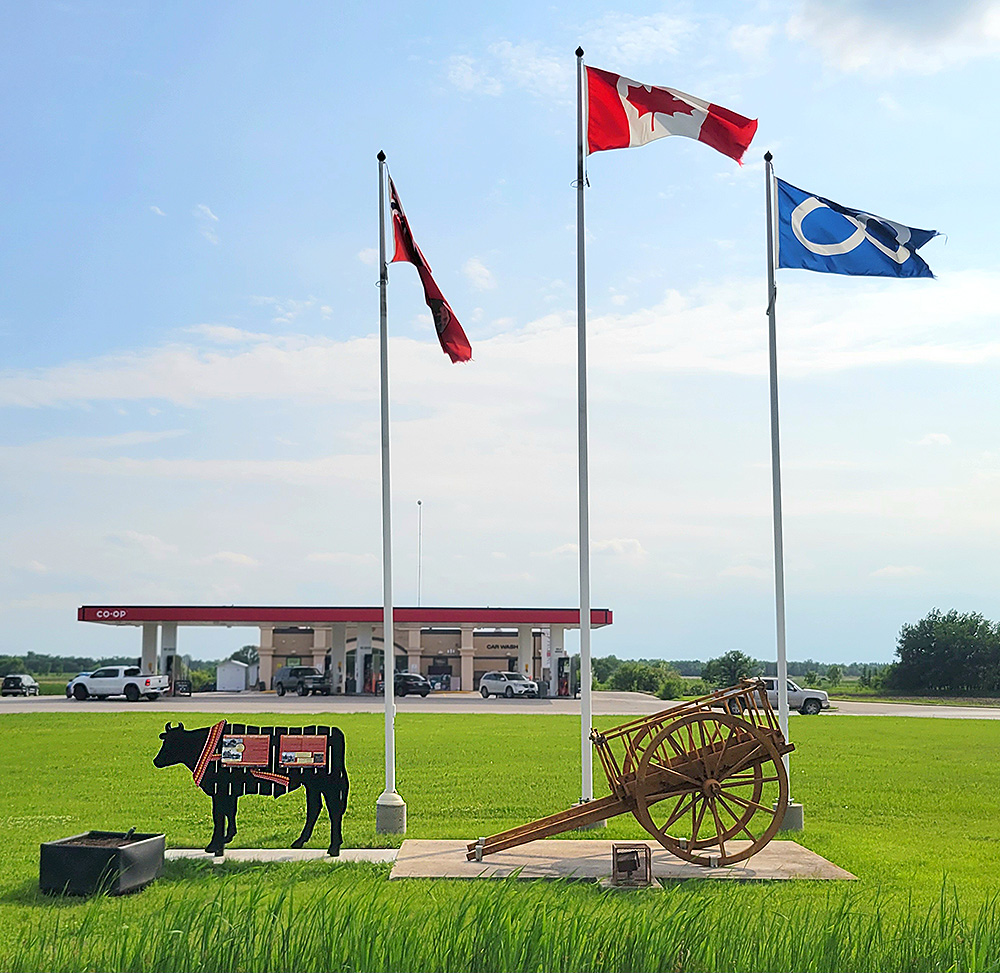
This exhibit was made possible through the efforts of the Dawson Trail Arts and Heritage Tour, with the permission of the Red River Coop Lorette and endorsement by the local Métis community. We credit Connelley Signs for the exhibit manufacturing, Pierrette Sherwood for the artistic concept and Myriam Dyck for her help with the ox design. Photo by Myriam Dyck.
Imagine yourself sitting on that hard wooden bench, bumping along a muddy trail through the woods day after day with your family and all your possessions? Travelling the early Dawson Trail was not for the faint of heart!
Ingenuity of the Red River Cart
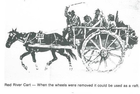
The Red River cart was made of wood and had two large wheels. Wooden pegs and strips of buffalo hide held the parts together. Strips of rawhide were wrapped around the wooden wheels. The carts squeaked loudly and could be heard for miles. The cart was usually pulled by oxen, so it was also called an ox-cart.
“The Red River Cart was a two-wheeled small wooden wagon pulled by oxen and used extensively from the 1820s until the 1880s when the railroad replaced it. The cart had several advantages: It could be built with local wood; it could be repaired with found wood; it could be converted to a raft when the wheels were taken off in order to cross rivers; and it could haul a substantial amount of goods when pulled by oxen. Although horses purchased from Native Americans were first used, horses could not carry the heavy loads of furs; in fact, five horses were needed to replace one ox. (…) The carts were noisy, the wheels couldn’t be greased or, when dust and dirt missed with the grease, would become rigid and immovable.”
Indigenous Peoples Atlas of Canada, 2020
Source: Indigenous Peoples Atlas of Canada – Royal Canadian Geographical Society (Canadian Geographic). (2020). Red River Carts. Atlas / Métis. Retrieved June 23, 2020 from https://indigenouspeoplesatlasofcanada.ca/article/red-river-carts/
Blom, R.R. (1980, April). Taché Rural Municipality 1880-1980 (P.32). Commissioned by The Council of the Rural Municipality of Taché. Derksen Printers, Steinbach: Manitoba. Retrieved from University of Manitoba digital collections June 3, 2020, http://hdl.handle.net/10719/3055598 / https://digitalcollections.lib.umanitoba.ca/islandora/object/uofm%3A3055598#page/43/mode/2up
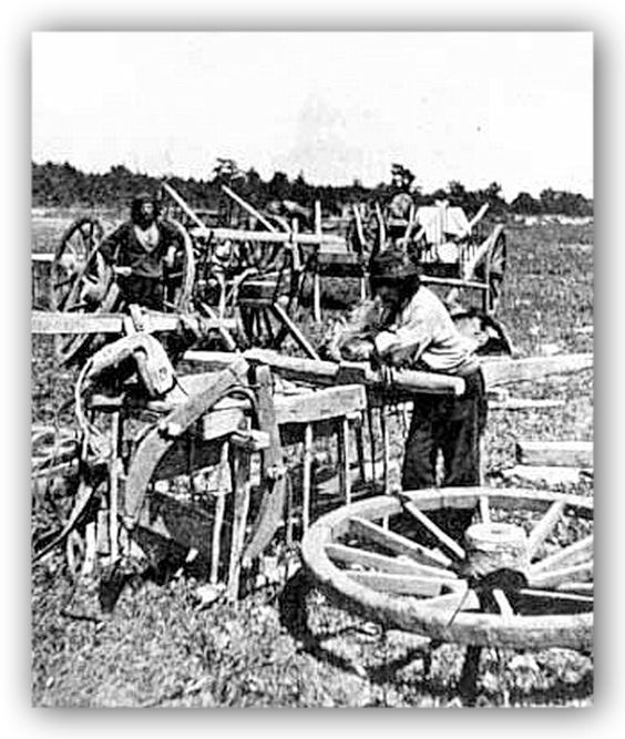
Red River Cart repair. “Repairs when required could readily be made on the trail where wood was available. When the dowel, connecting two sections of the felloe broke, two flat pieces of wood were cut to conform to the wheel curvature, and one piece was placed on each side of the felloe at the joint requiring repair and bound together with strips of animal hide, wound crosswise around the felloe, usually referred to as shagganappe, which had been soaked in water. When the strips dried they held the curved flat wooden boards firmly against the felloe and enabled the cart to travel to the nearest post where permanent repairs could be made.” Minnesota Historical Society. Preparing Red River cart for trip to St. Anthony Falls. Retrieved from http://collections.mnhs.org/cms/display.php?irn=10185641.
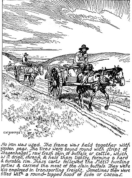
C.W. Jeffreys, artist. Red River cart train. CAScity. Retrieved June 4, 2020 from https://www.cascity.com/forumhall/index.php?topic=44831.25
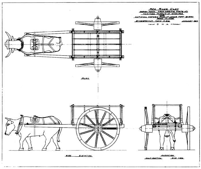
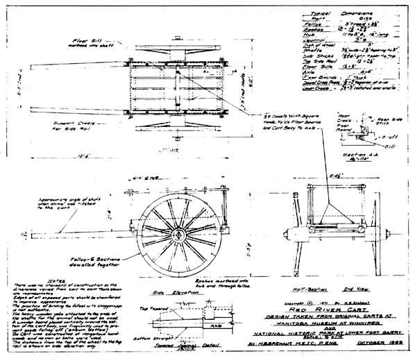
“The ‘dished’ wheel was an important development in the cart. The ‘dish’ was made by inclining the spokes outward from the cart body. The amount of the dish varied but was about 3 inches. It gave the cart better stability by preventing tipping on rough terrain and facilitated getting out when stuck in the mud. The dished wheel was also used as a raft when crossing rivers, by removing the wheels and lashing them together concave side upward. Then the cart body and cargo were placed upon them and ferried across the water.” Source: Baker Brehaut, H. (1871-71). The Red River Cart and Trails: The Fur Trade. Manitoba Historical Society. MHS Transactions, Series 3, Number 28. Retrieved June 4, 2020 from http://www.mhs.mb.ca/docs/transactions/3/redrivercart.shtml
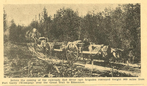
Corduroy road over the Souris River in Southwestern Manitoba a few hours west from the Dawson Trail; Provides a good idea as to what corduroy road looked like. This is the same method used to build the Dawson Road over swamps. Before the coming of the railroads Métis Red River Cart brigades conveyed freight 900 miles or 1,450 Km from Fort Garry (Winnipeg) to Edmonton. Source: Godsell, P.H. (1951). West to the Setting Sun (P.25). Canadian Cattlemen news. Lethbridge, Alberta. Retrieved June 24, 2020 from
https://static.canadiancattlemen.ca/wp-content/uploads/2018/05/West-to-the-Setting-Sun-Part-2.pdf#_ga=2.37729513.853683548.1583979767-1076917515.1583979767
Go to Next Tour Location: Notre Dame de Lorette Church | Top
Previous page: Prairie Grove
Next page: Notre Dame de Lorette Church