Falcon Lake Plaques
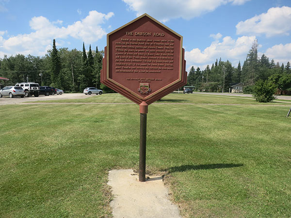
There are two commemorations for Dawson Road at Falcon Lake. The first plaque was erected in 1939 by the Historic Sites Advisory Board of Manitoba (seen below) and the second was erected in 1989 at the Falcon Lake Shopping Centre in Whiteshell Provincial Park by the Manitoba Heritage Council.
Plaque text at Falcon Lake Shopping Centre states: Parallel to this highway, about twenty miles to the south, ran the Dawson Road, first all-Canadian land and water route linking eastern and western Canada. From Fort William the route ran nearly 500 miles westerly, first by a series of rivers and lakes to Rainy Lake, Rainy River, and Lake of the Woods, thence overland to St. Boniface in the Red River Settlement. The road was begun in 1868 and completed in 1871. It was named for Simon James Dawson, noted Canadian land surveyor, who surveyed the route in 1858 and recommended that a road be constructed.
Source: Province of Manitoba. (n.d.). Manitoba Heritage Council Commemorative Plaques: Dawson Road. Historic Resources Branch. Retrieved June 21, 2020 from https://www.gov.mb.ca/chc/hrb/plaques/plaq0276.html
In 1939 a plaque was erected at Falcon Lake in Whiteshell Provincial Park by the Historic Sites Advisory Board of Manitoba to commemorate the Dawson Road as a route that linked Ontario to the new province of Manitoba. Manitoba Historical Society. Retrieved June 4, 2020 from Historic Sites of Manitoba: Dawson Road Plaque (Falcon Lake, Whiteshell Provincial Park)
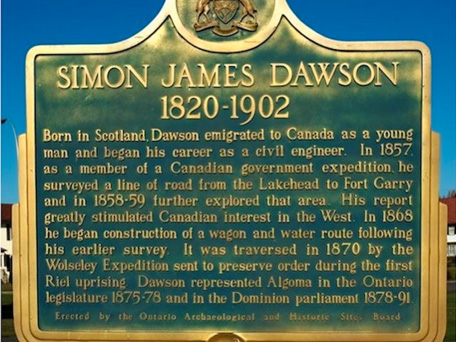
Commemorative Plaque in Thunder Bay
Plaque text reads: Born in Scotland, Dawson emigrated to Canada as a young man and began his career as a civil engineer. In 1857 as a member of a Canadian government expedition [Hind Expedition] he surveyed a line of road from the Lakehead to Fort Garry and in 1858-59, further explored that area. His report greatly stimulated Canadian interest in the West. In 1868, he began construction of a water and waggon route following his earlier survey. It was traversed in 1870 by the Wolseley Expedition sent to preserve order during the first Riel uprising. Dawson represented Algoma in the Ontario legislature 1875-78 and in the Dominion Parliament 1878-91.
Source: Ontario’s Historical Plaques. (2004-2019). Simon James Dawson (1820-1902) [Location : Thunder Bay]. « Discover Ontario’s history as told through its plaques ». Retrieved June 21, 2020 from http://ontarioplaques.com/Plaques/Plaque_ThunderBay29.html
Plaque in Thunder Bay, Ontario commemorating Simon J. Dawson’s contributions to stimulating interest in the West with the Dawson Trail. It is located beside the parking lot on Colonel Keene Drive in Hillcrest Park on High Street South, just south of Red River Road. Ontario Plaques. Photo by contributor Dave Fernie - Posted October, 2005. Retrieved from http://ontarioplaques.com/Plaques/Plaque_ThunderBay29.html
Parks Canada, National Historic Event plaque erected in Marina Park Unknown, Ontario, January 30, 1920 to commemorate Wolseley's Red River expeditionary force which camped in Port Arthur at the foot of Arthur Street in 1870. Retrieved from Port Arthur National Historic Event
NorthWest Angle Monument
A monument was placed at the east end of Dawson Road, known as Northwest Angle Monument in the 1880s. C.F. Friesen rests his hand on the boundary post marking the juncture of Manitoba and Ontario at the very northern tip of Northwest Angle, where the famous Dawson Trail hits the Lake of the Woods, and many a pioneer settler began a cruel trek through the swamps of southeastern Manitoba to start a new life in Canada’s newest province. In 1957, Mr. Friesen (seen below) was an 80 year-old pensioner. He explained that “while the swamps are frozen, the winter roads are in good condition all the way from Middlebro north to the Trans-Canada Highway.”
Wes Keating, local journalist
Source: Steinbach Carillon, Steinbach, Manitoba, CA, October 30, 2014, Page 21, Flashback - “Discovering the Dawson Trail: Waggon Route is a Gateway to the West” by Wes Keating. Retrieved June 8, 2020 from https://newspaperarchive.com/anniversary-clipping-oct-30-2014-1800452/
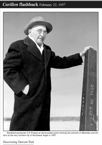
C.F. Friesen at the boundary post, Northwest Angle, 1957. Source: Steinbach Carillon, Steinbach, Manitoba, CA, October 30, 2014 (P.21), Flashback - “Discovering the Dawson Trail: Waggon Route is a Gateway to the West” by Wes Keating. Retrieved June 8, 2020 from https://newspaperarchive.com/anniversary-clipping-oct-30-2014-1800452/
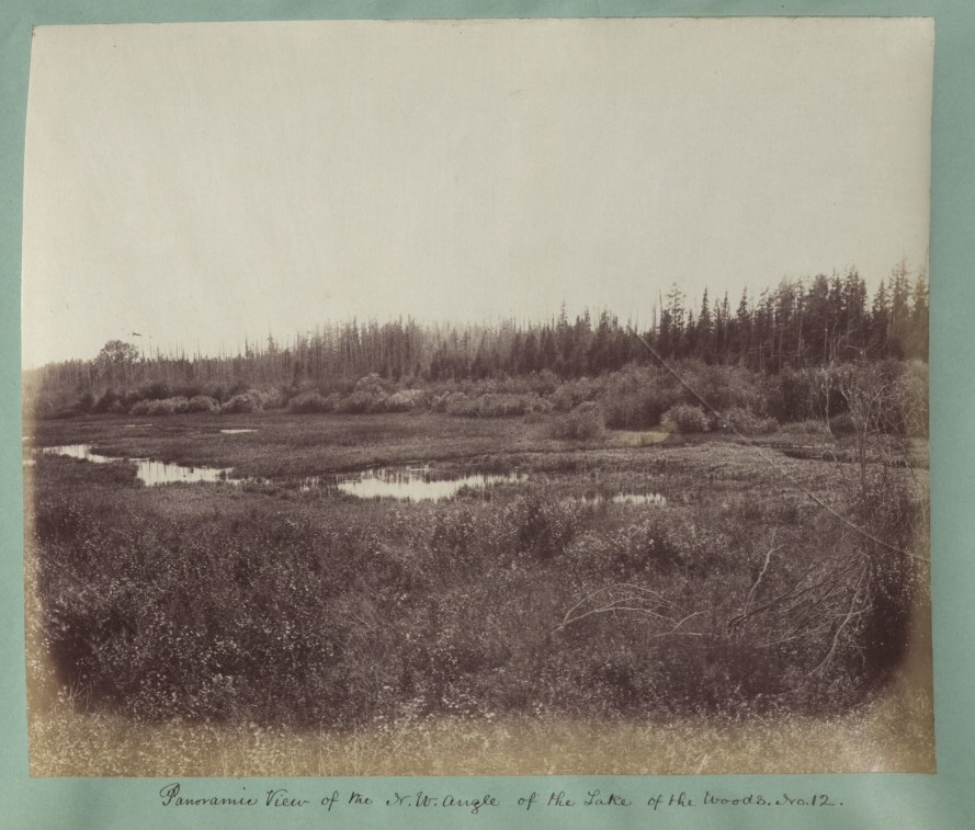
Panoramic view of the NorthWest Angle of the Lake of the Woods, No 12 (1876). The National Archives, UK CO 1069-272-10. Retrieved June 23, 2020 from https://www.flickr.com/photos/nationalarchives/7457050184/in/photostream/
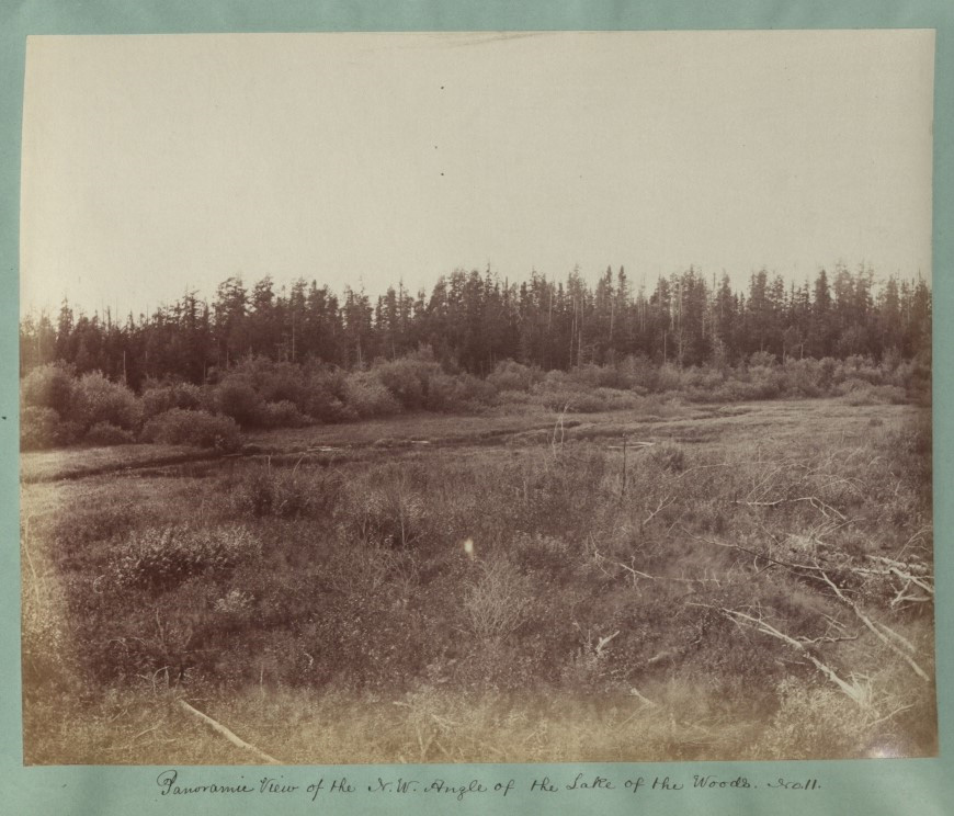
Panoramic View of the NorthWest Angle of the Lake of the Woods, No 11, (1876). National Archives, UK. CO 1069-272-9. Part of the Colonial Office Photographic Collection. Retrieved from https://www.flickr.com/photos/nationalarchives/7457051536/in/photostream/
Next: Dawson Trail: Symbol of Togetherness | Top
Previous page: The Dawson Trail : A Centennial Project
Next page: Dawson Trail: Symbol of Togetherness