“For 200 years, the Hudson’s Bay Company had “owned” the vast expanse of North America that drains into Hudson Bay. In 1868, Britain purchased the territory and transferred ownership to the new Dominion of Canada pursuant to the Rupert’s Land Act. It was the largest land purchase in Canadian history, comprising most of what are now the Prairie provinces and parts of northern Quebec, northern Ontario, the Northwest Territories and Nunavut. Canada secured a new frontier for settlement; the company received £300,000* and 20 percent of the territory’s arable land. In 1870, the transfer became official and title to Rupert’s Land (and the adjacent North West Territory) passed to Canada. The Inuit, First Nations and Métis who lived in this vast region were not consulted in the matter. The Red River Métis, who were the most immediately affected, took up arms under the leadership of Louis Riel.”
Benjamin Dolittle in a blog for FourtyBee, 2020
*£300,000 is the equivalent of about $1.5M Canadian dollars
Source: Doolittle, B. (2020, Jan 10). Great Britain’s Claims of Ownership of Native Peoples Lands. FourtyBee/Blog/History. Retrieved June 21, 2020 from https://fourtybee.com/history/great-britains-claims-of-ownership-of-native-peoples-lands/
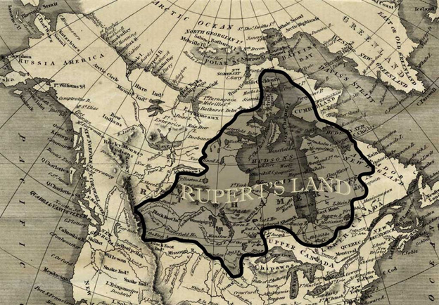
Map of Rupertsland in 1869 under HBC regime prior to sale to Canada. Source: FourtyBee.com. Retrieved June 8, 2020 from Rupert's Land • FourtyBee
“In 1859, Dawson submitted a report proposing a combined land and water route to Red River. The eastern section of the route was to follow the old canoe routes to the NorthWest Angle. Dawson suggested that a railroad 91 ½ miles in length, be constructed to link the Lake of the Woods with the Red River, and thereby avoid the treacherous rapids of the Winnipeg River. It was along the route of the proposed railway that the Dawson Road was eventually built. Although the Dawson Road sparked a great deal of interest in the North-West, it also was very discouraging. The cost of the proposed route would be enormous and nobody was even positive that it could be built efficiently. For nine years the report gathered dust. In 1868, [with the imminent sale of Rupertsland to Canada] Dawson was employed to open communications with the Red River country by what was later known as the “Dawson Route”.
Nik Feilberg, local farmer and historian from East Braintree
1989
Source: Feilberg, E., & Annell, L. (1989). ‘Simon J. Dawson by Nik Feilberg’ (P.16). Pioneer History of Glenn, East Braintree & McMunn.). Retrieved June 21, 2020 from http://hdl.handle.net/10719/2239350
Back to St. Boniface Heritage Tour page | Top
Previous page: A Rich History
Next page: Simon J. Dawson: Surveyor, Civil Engineer, Office Holder, and Politician