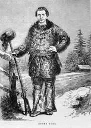
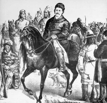
Louis Riel, leader of the Métis during the time of the construction of the Dawson Road and the Resistance that led to the founding of Manitoba. Source image (left): The Begbie Contest Society. (n.d.) Canadian Primary Sources in the Classroom – Riel and Manitoba. Multiple Perspectives. Retrieved June 29, 2020 from http://www.begbiecontestsociety.org/RIEL%20and%20MANITOBA.htm Source image (right): Famous-trials. (n.d). “Riel on Horseback with Rebel Leaders,” drawing by William Bengaugh, 1885 in The Trial of Louis Riel: Selected Images [website]. Retrieved June 30, 2020 from https://famous-trials.com/legacyftrials/riel/imagepage.html
“Sometime in 1869, Riel staked a claim at the east end of what later became the parish of Lorette. It was described as follows by Roger Goulet when he investigated the Lorette claims in 1875:
"Beginning at corner post at the South West corner of Section 9, Tp. 9, R. 6 East, measuring from said post East along line between said Section 9 and 4, 20 chains a claim post is found distant, South 2 chains from said line, planted by Louis Riel before transfer; continuing to measure East 8 chains on aforesaid line, thence due North 12 chains and thence due West 4 chains is found a square of poplar logs 15 x 15 links 8 logs high, put up also by Louis Riel before transfer; that building is between the fork of Seine River near where it takes it[s] sources from the big swamp West of St. Anne Pointe de Chenes. I have not been able to ascertain frontage of said claim. I was told it is meant to be two miles in length on South side of River. [14]
"For reasons that are unclear, Riel’s claim was not incorporated into the river-lot survey of the parish of Lorette. But George McPhillips, the Dominion Lands Surveyor, was aware of it, as shown by the illustration on page 5, a drawing from his field notes. “Logs crossed,” wrote McPhillips in 1877 in his notebook, “to mark claim of heirs of the late Riel.” [15] (His reference to the “heirs of the late Riel,” i.e., Riel’s father, suggests that other members of the family were involved in the claim in a way not revealed by the available sources.)”
Thomas Flanagan, University of Calgary
Source: Flanagan, T. (1991). Louis Riel’s Land Claims. Manitoba History, Number 21, Spring 1991. Manitoba Historical Society. Retrieved June 28, 2020 from http://www.mhs.mb.ca/docs/mb_history/21/riellandclaims.shtml
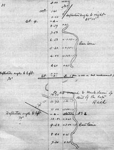
Surveyor George McPhillips records the Louis Riel property between Lorette and Dufresne in his field notes for the Lorette Survey 1877. To this day Riel’s land claims in the area are outstanding. Image source: Flanagan, T. (1991). Louis Riel’s Land Claims. Manitoba History, Number 21, Spring 1991. Manitoba Historical Society. Image Source: Archives of Manitoba Retrieved June 28, 2020 from http://www.mhs.mb.ca/docs/mb_history/21/riellandclaims.shtml
"McPhillips described Riel’s claim as “Claim E”, lying just outside the limits of the parish:
“Limits of claim could not be definitely ascertained. Mr. Goulet thinks the claim is on south bank of Seine and ten chains wide by 160 chains long. A number of logs piled in the shape of a house were on lot in 1872 and a few logs are still there.”
"Riel was aware that the criteria for possession of land would be different under Canadian law than under the custom of the country that had prevailed in Red River. He wrote to his mother on May, 1872, when he was in exile in St. Paul, Minnesota:
“Dear Mother, please ask Nanin (André Nault, Riel’s cousin) if he will go as fast as he can to plow an acre or two on my land below Lake Norman (lac à Norman). Sow barley and make it obvious. Pay him yourself or I will send him the money. Please don’t delay in getting that done, and let me know as soon as possible if the government starts digging a canal there.” (translation)
Thomas Flanagan, University of Calgary
Source: Flanagan, T. (1991). Louis Riel’s Land Claims. Manitoba History, Number 21, Spring 1991. Manitoba Historical Society. Retrieved June 28, 2020 from http://www.mhs.mb.ca/docs/mb_history/21/riellandclaims.shtml
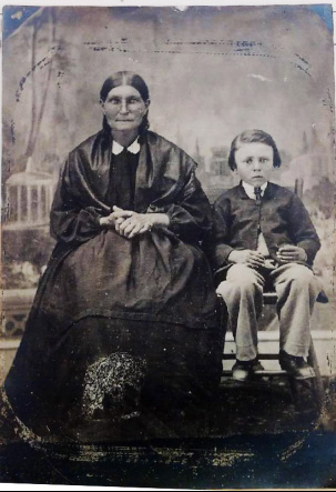
Louis Riel’s mother (née Julie Lagimodière), Riel, Mrs. Louis Riel Sr. 1 (and unidentified boy), (1866-1871) N9970, Archives of Manitoba. www.mhs.mb.ca/docs/mb_history/11/archivalresources.shtml
“The reference to “lac à Norman” is obscure, but the other details show that Riel was writing about his land claim near Lorette. André Nault had claims of his own nearby, so it would not have been inconvenient to plow a couple of acres for Riel. The mention of a canal is also indicative. Riel’s claim, according to Roger Goulet, lay near the “big swamp” that was the source of the Seine River.
"Based on the above description, Riel’s parcel of land is believed to have been roughly the equivalent of 80 acres and located somewhere South of where the Dufresne grain elevator can be found today.”
Thomas Flanagan, University of Calgary
Source: Flanagan, T. (1991). Louis Riel’s Land Claims. Manitoba History, Number 21, Spring 1991. Manitoba Historical Society. Retrieved June 28, 2020 from http://www.mhs.mb.ca/docs/mb_history/21/riellandclaims.shtml
Back to Dufresne Grain Elevator Heritage Tour page | Top
Previous page: The Legendary Midwinter Tramp of a Famous Lorette Resident
Next page: Rich Floras Leading to and past Pointe des chênes