POINT OF INTEREST: East End of the Current Dawson Trail
Brokenhead: Eastern Boundary of the “Postage Stamp Province of 1870”
HISTORICAL NUGGETS:
Birch River Station for Weary Travelers
East End of Current Dawson Road PTH #207
SEE GOOGLE MAP LOCATION 
The Eastman ATV Staging Area is the east end of today's currently driveable Dawson Trail, at the corner of Dawson Trail and Rd. #19A. There is an extensive network of trails extending southeastward but they are not maintained roads and are for recreational use only.
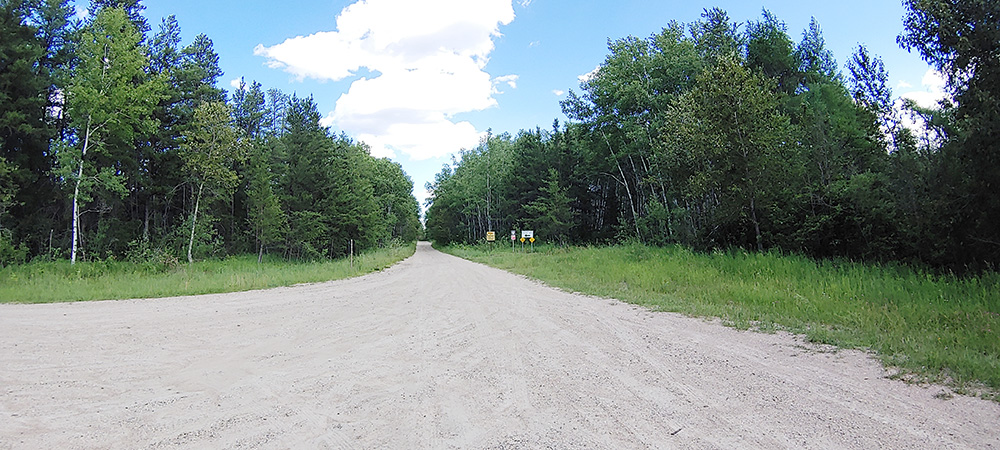
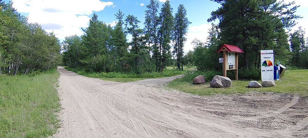
 You are welcome to drive in the first couple hundred meters of the trail to the parking area (if the road is good and you have a suitable vehicle - unmaintained road) and go for a hike if you want to explore, but keep in mind that recreational vehicles have priority on the trails and that there is a lot of wildlife in the area so be cautious.
This is the beginning of Sandilands Provincial Park and just a few miles to the east of this point the terrain changes again to more deciduous trees, ferns, wild blueberries and swampy muskeg. This is Canadian Shield forest and it is similar to many parts of Ontario. From here east to the Ontario border, and down all the way southeastward to Lake of the Woods, is known as the Northwest Angle.
The final marker at Harrison Creek is not accessible by road, only by snowmobile over winter roads - you can read all about the Harrison Creek marker here.
Heritage Tour Directions - 3 options:
- There is another accessible marker at East Braintree, approximately 50 kilometres eastward and down some gravel roads. IF you have plenty of time and want to see it, please proceed to the East Braintree Marker.
We recommend you drive north from from the Eastman ATV Staging area 1 km to the Trans-Canada Highway #1, turn east and go 47.6 kms, then turn right onto MB-308 S (signs for East Braintree) and go south for 2.4 kms, then turn right onto E. Braintree Rd. for 7.4 kms. - IF you have some more time but don't want to drive the extra 100km round trip to East Braintree, please proceed to the Ross Church Bell Monument location.
We recommend you drive north from the Eastman ATV Staging area 1 km to the Trans-Canada Highway #1 then left (west) west 14 kms to Richer. At Richer, turn right (north) on Hwy #302 and go 10 kms until you reach Hwy #501, then turn right (east) and go 1.5 kms, then turn left (north) on Municipal Rd. #45E to arrive at your next Tour Location of Ross, Manitoba.
- IF you are really out of time and have to head back to the city, go straight west on Hwy #1 Trans-Canada Highway to the Centre of Canada Park, but don't forget to read about other locations and nuggets in Ross and Ste Genevieve along the way!
We recommend you drive north from from the Eastman ATV Staging area 1 km to the Trans-Canada Highway #1 then left (west) west 49 kms, watch for the park on the north side of Hwy #1.
Keep reading the many "Nuggets" about the Northwest Angle as you drive!
Brokenhead: Eastern Boundary of the “Postage Stamp Province of 1870”
On March 23, 1870, Father Noël-Joseph Ritchot and two other delegates from the Provisional Government left Red River for Ottawa. Louis Riel advised that a new province be created and called either “Manitoba” or “Northwest”.
On May 14, 1870, the new province of Manitoba was created. It was then referred to as “the Postage Stamp Province”, as it was only 100 square miles.
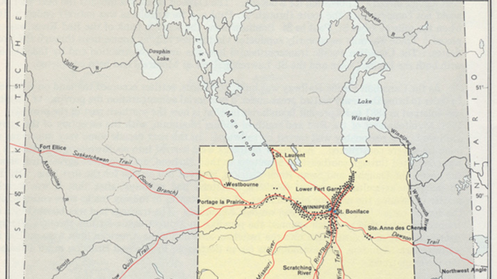
Map of the 1870 postage-stamp Province of Manitoba. One dot represents 50 people, so there were approximately 300 settlers already in the Ste-Anne-des-Chênes region at the time, but few in Lorette. Hallowell, A. Irving (Alfred Irving), and Jennifer S. H. Brown. 1991. “Ojibwa Of Berens River, Manitoba: Ethnography Into History.” Case Studies In Cultural Anthropology. Fort Worth: Harcourt Brace Jovanovich College Publishers. Source: Dibaajimowin. (2018, Dec 29), The Postage Stamp Province. Retrieved June 29, 2020 from https://www.dibaajimowin.com/metis/the-postage-stamp-province
“The sun had set before we arrived at Brokenhead Creek, only half way to Oak Point (Pointe-des-chênes). Somewhere hereabouts is the Eastern boundary of Manitoba, and we are not likely to forget soon the rough greeting the new Province gave us…” “…the rain poured down furiously and made the roads worse… The black flies worried us to madness and we were all heavy with sleep. The hours dragged miserably on and the night seemed endless.”
Sir Sanford Fleming describing his experiences along the Dawson Road in 1872
Source: Grant, G.M., 1835-1902. (1873). Ocean to ocean: Sandford Fleming’s expedition through Canada in 1872. Being a diary kept during a journey from the Atlantic to the Pacific with the expedition of the engineer-in-chief of the Canadian Pacific and Intercolonial railways (P.61). BC Historical Books. Diaries. Retrieved June 3, 2020, from https://open.library.ubc.ca/collections/bcbooks/items/1.0221770
Go to Next Tour Location: East Braintree Marker | Top
Previous page: Brokenhead River Crossing
Next page: East Braintree