“The Red River Expedition” in 1870-71 was known as the Wolseley Expedition, though several Red River Expeditions followed Wolseley’s until the mid-1870s but only the first expedition had to cut through the bush to make the opening for Dawson Road. Information from the London Illustrated News depicts a scene on the way to stop the Métis Resistance and demands for recognition of their rights, transfer power from the Provisional Government to the Dominion of Canada by force under the guise of being heroes for bringing supplies to help feed starving settlers in the Red River Colony as a result of locusts.
Arguably adding 1200 mouths to feed in the Red River Valley in a time of want for food and disappearance of the bison may not have done as much to help the settlement as suggested in the past, but it was a good story for the newspapers in Toronto and left the impression out East that it wasn’t actually the hostile takeover of the West that it was, but rather a glorious beginning to a colonized West as part of the idea of Canada as a nation.
Meanwhile, the news that Wolseley’s troops were advancing on Red River gave license to those settlers with the prevailing racist attitudes of the newcomers who believed they owned the west by God given right and that this entitled them to behave in discriminatory ways toward First Nations and Métis.
Incidents of violence and terror escalated in the colony when Wolseley’s army reached the Red River and Louis Riel was gone. After the Red River Resistance and the formation of the Province of Manitoba (post-1870), soldiers in Wolseley’s army were given land grants of 160 acres each for their service to the country, while Métis were having their lands taken away via a corrupt Métis Scrip system and that resulted in a mass exodus of Métis from Manitoba.
Source: Captain G.L. Huyshe. London Illustrated News, 28 Oct., 1871 (P.404).
“Upon his arrival, Simpson addressed a gathering of approximately 1,500 Saulteaux. He informed them that a military expedition would be travelling through their lands in order to get to the Red River. Simpson stressed that the troops meant them no harm and should therefore not be hindered in their travel. He also offered to hire some Saulteaux as workers and guides for the expedition.
"The Saulteaux refused this work offer but agreed not to interfere with the troops’ movement. They also made it clear that they expected to be paid for the construction of any roads or waterways through their territory. They requested $10 per man, woman and child annually for “as long as the sun shines.” The Saulteaux also wanted rations of pork, tea, tobacco and flour to be used in celebrations conducted when the government distributed the annual payments.
"Although the Saulteaux were ready to negotiate a treaty, they made it clear to Simpson that they had no intention of permitting “farmers to settle” on their land. This indicates that they did not intend to cede their rights to the land; they wanted compensation in exchange for allowing the development of specific government projects on their territory.”
Michelle Filice for The Canadian Encyclopedia, 2020
Source: Filice, M. (2016-2020). Treaty 3. The Canadian Encyclopedia. Retrieved June 27, 2020 from https://www.thecanadianencyclopedia.ca/en/article/treaty-3
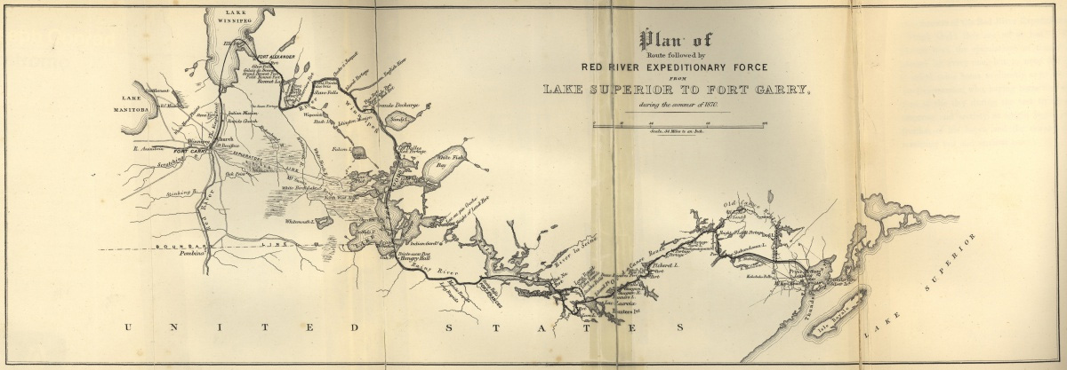
Plan of Route followed by Red River Expeditionary Force from Lake Superior to Fort Garry 1870-71 using the maps Dawson had drawn up in 1857-58 and updated in 1869-70. Province of Manitoba. Retrieved from The Wolseley Expedition | Provincial Plaques | Historic Resources Branch
“In 2017, The Red River Expedition of 1870 (also known as the Wolseley Expedition) was commemorated as a national historic event in “overseeing the hand-over of power from the Métis provisional government to the Dominion; symbolic in Crown-Aboriginal relations in Canada”. A plaque was installed in Bonnycastle Park next to the Upper Fort Garry Interpretive Park in Winnipeg.
"In 1920 a plaque was erected by the Historic Sites and Monuments Board of Canada in Port Arthur, Thunder Bay where Colonel Wolseley’s Red River Expedition camped on Arthur Street. The commemoration states: “1869 Simon Dawson established the eastern terminus of the Canadian government's proposed land and water communication between Lake Superior and the Red River on Thunder Bay just north of Fort William. The next year, when Colonel Garnet Wolseley led the Canadian Expeditionary Force over the Dawson Road to quell the Red River resistance, he named his camp here Prince Arthur's Landing. Renamed Port Arthur in 1882, it was the site of C.P.R.'s first grain elevator in 1883, and became a terminus of the Canadian Northern Railway in 1902.”
Parks Canada, Port Arthur National Historic Event Designation, 1920
Source: Parks Canada. Port Arthur National Historic Event. Directory of Federal Heritage Designations. Retrieved June 15, 2020 from https://www.pc.gc.ca/apps/dfhd/page_nhs_eng.aspx?id=1736&i=64407
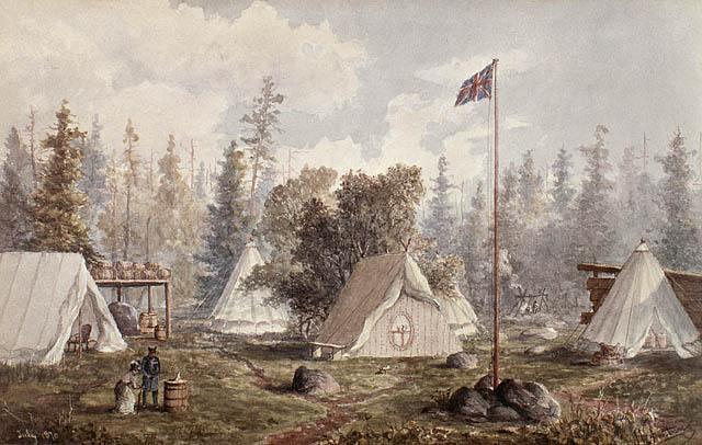
Red River Expedition, Colonel Wolseley's camp, Prince Arthur's Landing, Lake Superior 1870, by William Armstrong. Armstrong was an artist, civil engineer, photographer, and draughtsman. He accompanied Colonel Garnet Wolseley during the Red River Expedition as its chief engineer. Many of his views of the Red River Expedition were published in the Canadian Illustrated News and were well received by Protestants and Orangemen in Ontario as they eagerly followed reports of the expedition's progress to take the West for Canada. Library and Archives Canada/William Armstrong fonds/c011749k. Retrieved from https://www.collectionscanada.gc.ca/canadian-west/052910/05291041_e.html
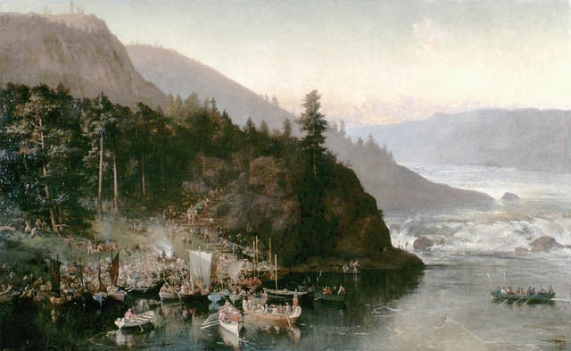
“Red River Expedition at Kakabeka Falls, Ontario by Frances Ann Hopkins, 1877.” The expedition to Red River was a considerable feat for Canada's young militia. The expedition required more than a thousand boats and several hundred voyageurs to transport the 1,200 troops and their supplies over the unfinished Dawson Road to Red River. As hinted at in Hopkins' view of the militia's portage at Kakabeka Falls, the logistics of moving such a large contingent through the wilderness were considerable. When it finally arrived in Red River after four months en route, Louis Riel and other Métis leaders had already fled to the United States. Library and Archives Canada/Frances Anne Hopkins fonds/e011154374.
Retrieved from The Red River Expedition at Kakabeka Falls, Ontario, 1877, by Frances Anne Hopkins - The Canadian West - Exhibitions - Library and Archives Canada
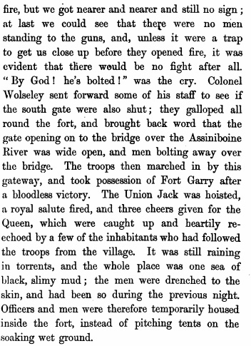
“...and these heavy burdens were carried on the backs of the men. Some of them used “portage straps” consisting of a band of leather 3 ¼ in. broad, which rests upon the forehead, while its two ends are fastened round the package behind, which is held in its place by the hands. Others preferred letting the burden rest on a pair of slings between two poles, which were supported by two men, each man walking between the poles, as in a sedan-chair, and either holding them in his two hands or suspending them by straps to his shoulders. The men endured their great fatigues and continual exposure to the wet in the most praiseworthy manner; none of them complained, and none suffered in health. They had not a drop of alcoholic or fermented liquor all the way; tea or coffee, with sugar, was the only stimulant allowed. Their daily rations were of biscuits, 1lb of salt pork, 1lb and one third of a pint of beans, or ¼ lb of potatoes. Upon this fare, alike for officers and soldiers, and upon the teetotal principle with regard to drink, they worked fifteen hours a day, as hard as any men ever could work. They were constantly wet through, wet sometimes for days together.”
Capt. G.L. Huyshe, Rifle Brigade, Red River Expedition
as published in Illustrated London News, October 28, 1871
Source: Huyshe, Captain, G.L. (1871, October 28). The Red River Expedition: Mr. Dawson’s Road (P.113-114). Rifle brigade, late on the staff of Colonel Sir Garnet Wolseley. London and New York. MacMillian and Co. Retrieved June 3, 2020 from https://books.google.ca/books?id=8A8WAAAAYAAJ...
“Wolseley's Troops enter the Fort,” 1870. LAC, Acc. No. 1934-39, ca. 1938. The Begbie Contest Society. (n.d.) Canadian Primary Sources in the Classroom – Riel and Manitoba. Multiple Perspectives. Retrieved June 29, 2020 from http://www.begbiecontestsociety.org/RIEL%20and%20MANITOBA.htm
Huyshe, Captain, G.L. (1871). The Red River Expedition: Mr. Dawson’s Road (P.196). Rifle brigade, late on the staff of Colonel Sir Garnet Wolseley. London and New York. MacMillian and Co. 276 pages. Retrieved June 3, 2020 from https://books.google.ca/books?id=8A8WAAAAYAAJ...
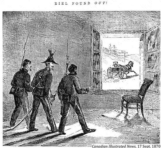
Illustration of Louis Riel’s get-away just before soldiers of the Red River (Wolseley) Expedition could apprehend him at Fort Garry. Some say his breakfast was still hot on the table when they entered. "Most of us felt that we had to settle accounts quickly with Riel, who had murdered the Englishman, Mr. Scott. Had we caught him, he would have had no mercy." -Colonel Garnet Wolseley. Source: Begbie Contest Society, Riel and Manitoba — Riel et Manitoba. Original printed in the Canadian Illustrated News, September 17, 1870. Retrieved June 5, 2020 from http://www.begbiecontestsociety.org/RIEL%20and%20MANITOBA.htm
"The sheer brutality and volume of assaults was shocking in a community that had seen nothing of the kind before. Initially many people thought the newspaper accounts were exaggerated, but they weren't. (...). It took six weeks for The St. Paul Daily Pioneer to put a name to the violence. For the St. Paul paper to name it a "reign of terror" so quickly gives an indication of the level of violence in Red River. The St. Paul Daily Pioneer wrote that the troops intended "to drive out by threats or actual violence” all the French Métis."
Jean Teillet, Metis author, 2019
Source: Teillet, J. (2019). The North-West is Our Mother: The Story of Louis Riel’s People (p.248). Published by Patrick Crean Editions, an imprint of HarperCollins Publishers Ltd. Reference to St. Paul Daily Pioneer, The, St. Paul, Minn, USA (October 6, 1870). Retrieved June 22, 2020 from https://www.harpercollins.ca/9781443450140/the-north-west-is-our-mother/
Back to Centre of Canada Park Heritage Tour page | Top
Previous page: Scrip - ‘essentially the largest land swindle’
Next page: Dawson Route and Treaties No. 1 and No. 3