“Chief Na-sa-kee-by-ness (Flying Down Bird) or Les Grand Oreilles represented the Oak Point Nation and was one of the chiefs who met Archibald in the Fall of 1870 and demanded a treaty or compensation for keeping the peace. Na-sa-kee-by-ness spoke only briefly during the negotiations, but he was the first chief to bring up the issue of the Lake of the Woods road. The right-of-way associated with the Dawson road delayed the conclusion of negotiations at Fort Frances (referring to Treaty 3 negotiations), but the Lake of the Woods road had not been mentioned at Fort Garry (referring to Treaty 1 negotiations). Na-sa-kee-by-ness said, “I was camped along the Lake of the Woods road. Last fall you saw me there. Something was then promised me: but whenever I look along the road I see nothing. They spoke to me at the Fort here. What was promised me then?” Simpson replied, “By whom?” Na-sa-kee-by-ness answered that it was promised by John McTavish, (the HBC Factor of Upper Fort Garry). Simpson claimed that the HBC had nothing to do with the treaty before them, but George Kasias continued discussing Na-sa-kee-by-ness’ concern about the road. He said, “There is also something which you are using (Lake of the Woods road) for which my children ought to receive compensation … but I have not yet received anything for it. Where will my children get anything to shelter them from the heat? They expect it from the road.” Both Na-sa-kee-by-ness and Kasias made the point about shelter or housing and connected it to the permissions granted for construction of the Lake of the Woods road.
"Neither Archibald nor Simpson acknowledged the debt owing from the Lake of the Woods Road, but Na-sa-kee-by-ness continued, “Then I’ll make one request for my braves and councillors - I would like you to dress them.” This request also had its origins with the HBC and is the first request for coats for the chiefs and headmen. The suits were made of “a coarse cloth coat, either red or blue, lined with baize with regimental cuffs and collar. The waistcoat and breeches are of baize, the suit ornamented with broad and narrow orris lace of different colours; a white or checked shirt; a pair of yarn stockings tied below the knee with worsted gaiters; a pair of English shoes.” The HBC distributed the suits to recognize the authority of the chiefs to govern and the headmen’s suit recognized the authority to distribute justice and police their communities.
"Wa-sus-koo-koon was the speaker for chiefs Qu-a-ty-ash, Na-na-wyn-an and Wako-wish. In the first days of treaty negotiations Wa-sus-koo-koon said little and made his first speech on the fourth day claiming the territory from Red River to the international boundary and East to Pembina. The eyewitness account in The Manitoban claimed Wa-sus-koo-koon’s speech was “much more flowery than convincing, in support of this tremendous demand.” Wa-sus-koo-koon’s second speech also focused on land and questioned why they were to get “shut up on a small reserve.” He also asked if a man settles down with a family of five, and then has more children, “where is their land?” Archibald replied that when “his children get more numerous than they are now, they will be provided for further West. Whenever the reserves are found too small the Government will sell the land and give the Indians land elsewhere.” Hall considered Archibald’s response to be an “extraordinary promise” with two implications. The second, is that “the remark suggested the notion that the reserve settlement in the treaties was not necessarily final and unchangeable.” This would have appealed to the Treaty One chiefs as the Indigenous perspective of treaty-making was an ongoing relationship, which could be subject to change, rather than a static immutable written document.”
Sheldon Krasowski, PhD History thesis, University of Regina, 2011
Source: Krasowski, S.K. (2011, June). Mediating the Numbered Treaties: Eyewitness Accounts of Treaties Between the Crown and Indigenous Peoples, 1871-1876: A thesis submitted to the Faculty of Graduate Studies and Research in partial fulfilment of the requirements for the degree of Special Case Doctor of Philosophy in History (P.75-76). University of Regina. Retrieved June 26, 2020 from https://ourspace.uregina.ca/bitstream/handle/10294/3575/Krasowski_Sheldon_Phd_History_Fall2011.pdf?sequence=1
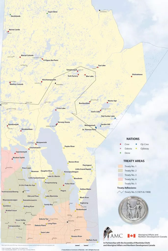
Map of the Numbered Treaties in Manitoba. Note that the route from Fort Garry to the NorthWest Angle via the Dawson Road crosses Treaty areas 1 and 3 in South-Eastern Manitoba. Treaty Relations Commission of Manitoba. (2020). [Map] Map of the Numbered Treaties. Retrieved July 2, 2020 from http://www.trcm.ca/treaties/treaties-in-manitoba/view-pdf-interactive-map-of-numbered-treaties-trcm-july-20-entry/
Back to Centre of Canada Park Heritage Tour page | Top
Previous page: Dawson Route and Treaties No. 1 and No. 3
Next page: Impact of the Homestead Act (1919)