“The Greater Winnipeg Water District Railway (and Aqueduct) cuts through the most easterly corner of the Municipality of Taché, and in its early years, greatly affected the growth of said Municipality. The G.W.W.D. was started in 1912 and completed around 1918. The cities of Winnipeg and St. Boniface require a more abundant supply of water and they decided to bring it in from Shoal Lake. For this they needed to construct a water line. To construct the water line, they needed some means of transporting men, supplies and equipment to and from Shoal Lake. There was no road and most of the terrain was muskeg, forest and stone. A railroad seemed the only practical solution and thus the G.W.W.D. came into existence. The G.W.W.D. obtained the greatest part of its revenue from hauling cordwood and pulpwood to the cities for consumption in their wood burning furnaces and stoves. (…) It followed that the residents would set up lumber camps and deliver their wood to the Railway. Some of the settlers in that region made a fairly good living cutting and hauling wood.”
Rose R. Blom, author of the centennial history book for the R.M of Taché, 1980
Source: Blom, R.R. (1980, April). Taché Rural Municipality 1880-1980 (p.28-29). Commissioned by The Council of the Rural Municipality of Taché. Derksen Printers, Steinbach: Manitoba. Retrieved from University of Manitoba digital collections June 3, 2020, http://hdl.handle.net/10719/3055598
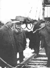
City of Winnipeg. (2020). Mayor Deacon drove the last spike 1914 near today’s Deacon’s corner along Dawson Road at the turn off for Lorette. Retrieved June 26, 2020 from https://winnipeg.ca/waterandwaste/dept/railway.stm
“People were employed by the G.W.W.D. to travel by canoe inside the aqueduct to inspect it for cracks or leaks. They had to pull the canoe out of the boat house at each river crossing and put it back in at the boat house on the other side. A part of the aqueduct called a "syphon" tunnels under the Boggy, Birch, Whitemouth and Red Rivers. A tricycle-like contraption was also used to inspect the inside of the aqueduct with one man, namely Cecil Norris, peddling all the way from Shoal Lake to Winnipeg. Nowadays modern laser equipment is used.”
Lorna Annell, Historian for the Midwinter Heritage Association
Source: Annell, L. (2019, Feb 25). “Planning a trip to East Braintree this year? Association of Manitoba Museums, Facebook page. Retrieved June 25, 2020 from https://www.facebook.com/Museums.Manitoba/posts/planning-a-trip-to-east-braintree-this-year-herere-some-things-you-might-like-to/1933081746814824/
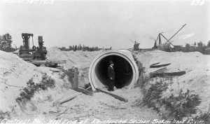
Engineers Geoscientists Manitoba. (2017, Jan 8). Circular pressure section of the Winnipeg Aqueduct during its construction at the turn of the last century, located west end of Brokenhead River. Retrieved June 26, 2020 from http://heritage.enggeomb.ca/index.php/Shoal_Lake_Aqueduct
Back to Ross Church Bell Monument Heritage Tour page | Top
Previous page: Manitoba Industrial Prison Farm
Next page: East Braintree G.W.W.D. Worker Camp